IMAGES TAKEN NEAR TO
Jubilee Croft, BRADFORD, BD11 1LZ
Introduction
This page details the photographs taken nearby to Jubilee Croft, BD11 1LZ by members of the Geograph project.
The Geograph project started in 2005 with the aim of publishing, organising and preserving representative images for every square kilometre of Great Britain, Ireland and the Isle of Man.

There are currently over 7.5m images from over14,400 individuals and you can help contribute to the project by visiting https://www.geograph.org.uk
Image Map (Loading...)


Getting Data...Please wait
Leaflet Map data © OpenStreetMap
Images are licensed for reuse under creativecommons.org/licenses/by-sa/2.0
Notes
- Clicking on the map will re-center to the selected point.
- The higher the marker number, the further away the image location is from the centre of the postcode.
Image Listing (79 Images Found)
Images are licensed for reuse under creativecommons.org/licenses/by-sa/2.0
Image
Details
Distance
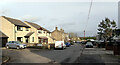
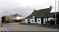
3
Houses, Jubilee Croft off Old Lane
These houses are on the site of a Congregational Chapel which was still shown on the 1:10000 map of 1986. Records start in 1865.
Image: © Humphrey Bolton
Taken: 1 Nov 2012
0.02 miles
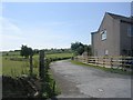
6
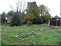
The Congregational graveyard, Old Lane
Image: © Humphrey Bolton
Taken: 1 Nov 2012
0.04 miles