IMAGES TAKEN NEAR TO
Kingsdale Gardens, BRADFORD, BD11 1EZ
Introduction
This page details the photographs taken nearby to Kingsdale Gardens, BD11 1EZ by members of the Geograph project.
The Geograph project started in 2005 with the aim of publishing, organising and preserving representative images for every square kilometre of Great Britain, Ireland and the Isle of Man.

There are currently over 7.5m images from over14,400 individuals and you can help contribute to the project by visiting https://www.geograph.org.uk
Image Map
Images are licensed for reuse under creativecommons.org/licenses/by-sa/2.0
Notes
- Clicking on the map will re-center to the selected point.
- The higher the marker number, the further away the image location is from the centre of the postcode.
Image Listing (137 Images Found)
Images are licensed for reuse under creativecommons.org/licenses/by-sa/2.0
Image
Details
Distance
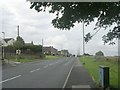
1
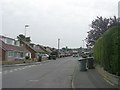
Kingsdale Gardens - viewed from Kingsdale Avenue
Image: © Betty Longbottom
Taken: 4 Jul 2011
0.06 miles
2
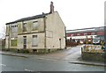
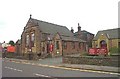
Derelict building, King Street, Drighlington
Image: © Humphrey Bolton
Taken: 30 Mar 2010
0.06 miles
3

Kingsdale Avenue - Kingsdale Gardens
Image: © Betty Longbottom
Taken: 4 Jul 2011
0.07 miles
4
Kingsdale Gardens - viewed from Kingsdale Avenue
Image: © Betty Longbottom
Taken: 4 Jul 2011
0.08 miles
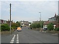
6
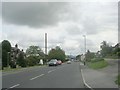
Moorside Road - viewed from Moorside Approach
Image: © Betty Longbottom
Taken: 23 Aug 2011
0.10 miles
8
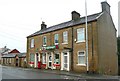
Drighlington Post Office, King Street
Image: © Humphrey Bolton
Taken: 30 Mar 2010
0.10 miles
9
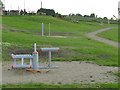
Outdoor exercise trail on Adwalton Moor
This telephoto view shows four of the ten exercise stations around a 300 metre circuit.
Image: © Stephen Craven
Taken: 15 Jun 2020
0.10 miles
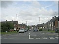
10
Moorside Road - viewed from Moorside Approach
Image: © Betty Longbottom
Taken: 23 Aug 2011
0.11 miles