IMAGES TAKEN NEAR TO
Place De Criel, NELSON, BB9 9AN
Introduction
This page details the photographs taken nearby to Place De Criel, BB9 9AN by members of the Geograph project.
The Geograph project started in 2005 with the aim of publishing, organising and preserving representative images for every square kilometre of Great Britain, Ireland and the Isle of Man.

There are currently over 7.5m images from over14,400 individuals and you can help contribute to the project by visiting https://www.geograph.org.uk
Image Map (Loading...)


Getting Data...Please wait
Leaflet Map data © OpenStreetMap
Images are licensed for reuse under creativecommons.org/licenses/by-sa/2.0
Notes
- Clicking on the map will re-center to the selected point.
- The higher the marker number, the further away the image location is from the centre of the postcode.
Image Listing (224 Images Found)
Images are licensed for reuse under creativecommons.org/licenses/by-sa/2.0
Image
Details
Distance
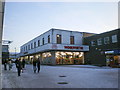
5
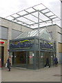
"Pendle Rise" Shopping Centre, Nelson, BB9 9SL
Many locals still call this "The Arndale"
Image: © Robert Wade
Taken: 28 Apr 2010
0.02 miles
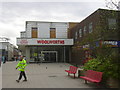
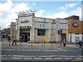
6
"Fultons Foods" (Was Woolworths) Unit 1 Place de Criel, Nelson
Image: © Robert Wade
Taken: 23 Aug 2011
0.02 miles
7
"Pendle Rise" Shopping Centre, Nelson, BB9 9SL
Image: © Robert Wade
Taken: 19 May 2011
0.02 miles
8
Pendle Rise Shopping Centre, Nelson
On two levels.
Image: © JThomas
Taken: 2 Aug 2018
0.03 miles
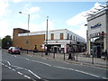
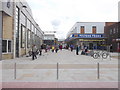
9
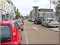
De-Pedestrianisation Manchester Road, Nelson, Lancashire
At huge cost the road has been reinstated for vehicles travelling West to East
Image: © Robert Wade
Taken: 23 Aug 2011
0.03 miles
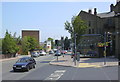
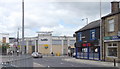
10
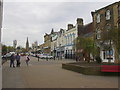
Manchester Road
Looking towards Burnley
Image: © Robert Wade
Taken: 28 Apr 2010
0.03 miles