IMAGES TAKEN NEAR TO
Back Harry Street, NELSON, BB9 8QD
Introduction
This page details the photographs taken nearby to Back Harry Street, BB9 8QD by members of the Geograph project.
The Geograph project started in 2005 with the aim of publishing, organising and preserving representative images for every square kilometre of Great Britain, Ireland and the Isle of Man.

There are currently over 7.5m images from over14,400 individuals and you can help contribute to the project by visiting https://www.geograph.org.uk
Image Map (Loading...)


Getting Data...Please wait
Leaflet Map data © OpenStreetMap
Images are licensed for reuse under creativecommons.org/licenses/by-sa/2.0
Notes
- Clicking on the map will re-center to the selected point.
- The higher the marker number, the further away the image location is from the centre of the postcode.
Image Listing (55 Images Found)
Images are licensed for reuse under creativecommons.org/licenses/by-sa/2.0
Image
Details
Distance
1
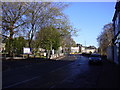
A682 the main street of Barrowford
Image: © Alexander P Kapp
Taken: 26 Nov 2007
0.03 miles
3
Gisburn Road, Barrowford
Part of the A682 which was a longstanding north-south route.
Image: © Bill Boaden
Taken: 27 Dec 2011
0.05 miles
5
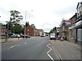
Gisburn Road (A682), Barrowford
Looking south.
Image: © JThomas
Taken: 2 Aug 2018
0.10 miles
6
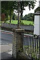
Lancashire Fingerpost
Now missing all of its fingers.
Image: © Andrew Riley
Taken: 9 Sep 2018
0.12 miles
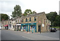
9
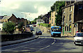
Road junction in Barrowford, Lancashire
This shows the junction of Gisburn Road (main road, part of the A682) with Church Street (in the centre). The latter road gives access to the Pendleside villages such as Fence, Wheatley Lane and Higham, while the A682 gives a route from the A56 in Barrowford to the A59 at Gisburn. The blue minibus displays route number 66, destination: Blacko, a village about two miles away up the A682.
Image: © Dr Neil Clifton
Taken: 12 Aug 1992
0.14 miles