IMAGES TAKEN NEAR TO
Algar Street, NELSON, BB9 8DX
Introduction
This page details the photographs taken nearby to Algar Street, BB9 8DX by members of the Geograph project.
The Geograph project started in 2005 with the aim of publishing, organising and preserving representative images for every square kilometre of Great Britain, Ireland and the Isle of Man.

There are currently over 7.5m images from over14,400 individuals and you can help contribute to the project by visiting https://www.geograph.org.uk
Image Map (36 Images)


Getting Data...Please wait
Leaflet Map data © OpenStreetMap
Images are licensed for reuse under creativecommons.org/licenses/by-sa/2.0
Notes
- Clicking on the map will re-center to the selected point.
- The higher the marker number, the further away the image location is from the centre of the postcode.
Image Listing (36 Images Found)
Images are licensed for reuse under creativecommons.org/licenses/by-sa/2.0
Image
Details
Distance
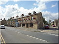
1
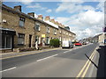
Leeds Road (A56), Nelson
Looking north east.
Image: © JThomas
Taken: 2 Aug 2018
0.05 miles
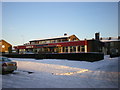
2
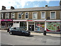
Funeral directors on Leeds Road (A56), Nelson
Image: © JThomas
Taken: 2 Aug 2018
0.06 miles
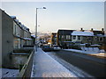
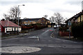
5
Nelson: Leeds Road
Looking northeast from the miniroundabout at the end of Reedyford Road. Leeds Road is the A56 and is the main route into Colne.
Image: © Dr Neil Clifton
Taken: 17 Mar 2010
0.11 miles
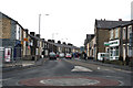
7
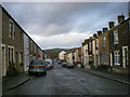
Nelson: Rakes House Road
Looking southeast from the crossroads with Regent Street. In this direction, Rakes House Road goes to Leeds Road.
Image: © Dr Neil Clifton
Taken: 17 Mar 2010
0.12 miles