IMAGES TAKEN NEAR TO
Gill Street, NELSON, BB9 7UD
Introduction
This page details the photographs taken nearby to Gill Street, BB9 7UD by members of the Geograph project.
The Geograph project started in 2005 with the aim of publishing, organising and preserving representative images for every square kilometre of Great Britain, Ireland and the Isle of Man.

There are currently over 7.5m images from over14,400 individuals and you can help contribute to the project by visiting https://www.geograph.org.uk
Image Map
Images are licensed for reuse under creativecommons.org/licenses/by-sa/2.0
Notes
- Clicking on the map will re-center to the selected point.
- The higher the marker number, the further away the image location is from the centre of the postcode.
Image Listing (69 Images Found)
Images are licensed for reuse under creativecommons.org/licenses/by-sa/2.0
Image
Details
Distance
1
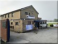
Nelson Cricket Club - Pavilion
Nelson CC play in the Lancashire Cricket League Division 1.
Image: © BatAndBall
Taken: 30 Apr 2019
0.04 miles
2
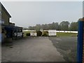
Nelson Cricket Club
Nelson CC's Seedhill Ground on a hazy morning.
Image: © BatAndBall
Taken: 30 Apr 2019
0.05 miles
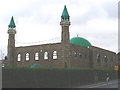
4
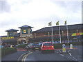
Nelson Morrisons
Next to the mosque.
Image: © Charles Rawding
Taken: 21 Jan 2005
0.07 miles
5
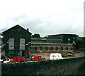
Nelson Pendle Street Shed
A room and power mill dated 1885, much of the site has been demolished
Image: © Alan Longbottom
Taken: 13 Aug 2007
0.11 miles
6
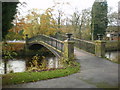
Footbridge over Pendle Water
In Victoria Park
Image: © Alexander P Kapp
Taken: 13 Nov 2009
0.12 miles
7
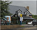
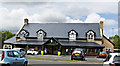
The Thatch and Thistle
A pub with a pay and display car park!
Image: © Ian Greig
Taken: 27 May 2016
0.12 miles
8
Victoria Park Nelson
Bridge over Pendle Water in Victoria Park, Nelson, Lancashire
Image: © Richard Dwyer
Taken: 23 Jul 2010
0.12 miles
10
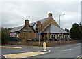
Thatch & Thistle, Hungry Horse public house, Nelson
Image: © JThomas
Taken: 2 Aug 2018
0.12 miles