IMAGES TAKEN NEAR TO
Clayton Street, NELSON, BB9 7NX
Introduction
This page details the photographs taken nearby to Clayton Street, BB9 7NX by members of the Geograph project.
The Geograph project started in 2005 with the aim of publishing, organising and preserving representative images for every square kilometre of Great Britain, Ireland and the Isle of Man.

There are currently over 7.5m images from over14,400 individuals and you can help contribute to the project by visiting https://www.geograph.org.uk
Image Map (Loading...)


Getting Data...Please wait
Leaflet Map data © OpenStreetMap
Images are licensed for reuse under creativecommons.org/licenses/by-sa/2.0
Notes
- Clicking on the map will re-center to the selected point.
- The higher the marker number, the further away the image location is from the centre of the postcode.
Image Listing (244 Images Found)
Images are licensed for reuse under creativecommons.org/licenses/by-sa/2.0
Image
Details
Distance
1
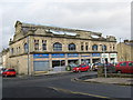
Nelson Library, Market Square Nelson Lancs BB9 7PU
Image: © Robert Wade
Taken: 28 Apr 2010
0.03 miles
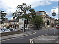
3
No need to tell lies
That you have been in Every Street in Nelson
Image: © Alexander P Kapp
Taken: 16 Jan 2009
0.05 miles
4
Former Textile School, Nelson, Lancashire
This old building on Every Street is marked as a Textile School on the 1912 OS map, but it is now subdivided between various small businesses. Opposite the school was the Market Hall, which burned down in 1932, after which that area was again used a (temporary) market, but has now become the Library car park.
Image: © Dr Neil Clifton
Taken: 7 Nov 2008
0.05 miles
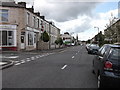
5
B6249 Carr Road-Every Street, Nelson, Lancashire
Image: © Robert Wade
Taken: 29 Jun 2011
0.05 miles
6
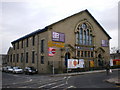
The Training Centre
Housed in a former church, the original church was built on what is now the car park on the right hand side
Image: © Alexander P Kapp
Taken: 16 Jan 2009
0.05 miles
7
"Closer Shave" (Barbers) Every Street, Nelson
Image: © Robert Wade
Taken: 29 Jun 2011
0.06 miles
8
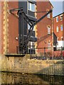
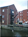
Loading Crane at Leeds and Liverpool Canal Warehouse, Nelson
The right-hand gable wall of Image] has altered two-stage loading doors served by an iron crane mounted on the quay and-attached to front corner of the warehouse.
See also Image],
Image] and
Image
Image: © David Dixon
Taken: 19 Mar 2015
0.06 miles
9
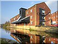
Warehouse on the Leeds and Liverpool Canal at Nelson
This canal warehouse, dating from ca 1876, was one of 9 new warehouses built for the Leeds-Liverpool Canal Company between 1874 and 1879 at various places between Leeds and Liverpool.
The three storey warehouse is of red brick in English bond, with sandstone quoins and dressings plinth of large dressed sandstone blocks, and slate roof. It has an almost rectangular plan, lying parallel to and immediately adjoining the canal. There is a pitched canopy at 1st-floor. The right-hand gable wall of has altered two-stage loading doors served by an iron crane mounted on the quay and-attached to front corner of the warehouse.
It is a grade II listed building (English Heritage Building ID: 448306 http://www.britishlistedbuildings.co.uk/en-448306-leeds-and-liverpool-canal-warehouse-nels British Listed Buildings).
See also Image],
Image]
and Image
Image: © David Dixon
Taken: 19 Mar 2015
0.06 miles