IMAGES TAKEN NEAR TO
Barley, NELSON, BB9 6LF
Introduction
This page details the photographs taken nearby to BB9 6LF by members of the Geograph project.
The Geograph project started in 2005 with the aim of publishing, organising and preserving representative images for every square kilometre of Great Britain, Ireland and the Isle of Man.

There are currently over 7.5m images from over14,400 individuals and you can help contribute to the project by visiting https://www.geograph.org.uk
Image Map
Images are licensed for reuse under creativecommons.org/licenses/by-sa/2.0
Notes
- Clicking on the map will re-center to the selected point.
- The higher the marker number, the further away the image location is from the centre of the postcode.
Image Listing (5 Images Found)
Images are licensed for reuse under creativecommons.org/licenses/by-sa/2.0
Image
Details
Distance
1
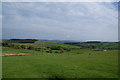
Path across the field
The path isn't very distinct. It provides an alternative longer route back down to Barley.
Image: © Bill Boaden
Taken: 23 May 2009
0.15 miles
3
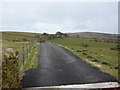
The road to Windy Harbour Farm
Another one of the many farms nestling in the shadow of Pendle Hill
Image: © Alexander P Kapp
Taken: 14 May 2006
0.22 miles
5
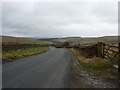
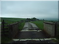
Barley Lane
Looking back down from the road to Windy Harbour Farm
Image: © Alexander P Kapp
Taken: 31 Mar 2010
0.25 miles