IMAGES TAKEN NEAR TO
Veevers Street, NELSON, BB9 5QQ
Introduction
This page details the photographs taken nearby to Veevers Street, BB9 5QQ by members of the Geograph project.
The Geograph project started in 2005 with the aim of publishing, organising and preserving representative images for every square kilometre of Great Britain, Ireland and the Isle of Man.

There are currently over 7.5m images from over14,400 individuals and you can help contribute to the project by visiting https://www.geograph.org.uk
Image Map
Images are licensed for reuse under creativecommons.org/licenses/by-sa/2.0
Notes
- Clicking on the map will re-center to the selected point.
- The higher the marker number, the further away the image location is from the centre of the postcode.
Image Listing (144 Images Found)
Images are licensed for reuse under creativecommons.org/licenses/by-sa/2.0
Image
Details
Distance
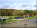
2
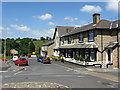
Clitheroe Road, Brierfield
This is now the B6248 linking Brierfield with the Pendleside villages, (Fence, Wheatley Lane, etc). Formerly the road was known as Lob Lane, and gave this name to the bridge, still so called, over the Leeds and Liverpool Canal
Image: © Dr Neil Clifton
Taken: 9 Jun 2008
0.02 miles
3
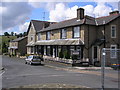
Houses on Clitheroe Road, Brierfield
When the M65 motorway was built, it was necessary to divert Clitheroe Road (the B6248) slightly to the south to make easier the construction of a bridge for this road over the motorway. Thus these houses were left slightly off the new alignment of the B6248, which diverged from the old alignment about where the photographer is standing.
Image: © Dr Neil Clifton
Taken: 15 Jul 2009
0.03 miles
4
Belgrave Street, Brierfield
Soon to be demolished to make way for modern houses
Image: © Alexander P Kapp
Taken: 14 Feb 2008
0.03 miles
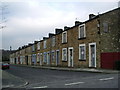
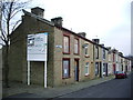
7
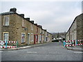
Berkeley Street, Brierfield, Lancashire
See also Image Since my previous photograph, the neighbouring streets, Claremont Street and Belgrave Street, have been completely demolished. On Berkeley Street itself, Nos 10, 12 and 14 remain inhabited, while of the others, 2,4 and 6 have been demolished, while 8, 16, 18 and 20 are 'tinned up'.
Image: © Dr Neil Clifton
Taken: 15 Jul 2009
0.06 miles
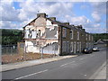
8
Claremont Street, Brierfield
All boarded up an ready for the bulldozer
Image: © Alexander P Kapp
Taken: 14 Feb 2008
0.06 miles
9
Claremont Street, Brierfield
Not just ready for the bulldozer, there are still people living here,not like the other side which is ready for demolition.
Image: © Alexander P Kapp
Taken: 14 Feb 2008
0.06 miles
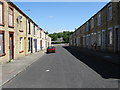
10
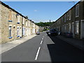
Berkeley Street, Brierfield
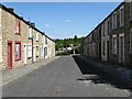
Off Clitheroe Road, Brierfield, are three streets of terrace houses, all of which are condemned and awaiting demolition. From east to west, they are Berkeley Street, Claremont Street, and Belgrave Street. A fourth street, Veevers Street, will have its eastern half demolished.
Image: © Dr Neil Clifton
Taken: 9 Jun 2008
0.06 miles