IMAGES TAKEN NEAR TO
Kibble Grove, NELSON, BB9 5EW
Introduction
This page details the photographs taken nearby to Kibble Grove, BB9 5EW by members of the Geograph project.
The Geograph project started in 2005 with the aim of publishing, organising and preserving representative images for every square kilometre of Great Britain, Ireland and the Isle of Man.

There are currently over 7.5m images from over14,400 individuals and you can help contribute to the project by visiting https://www.geograph.org.uk
Image Map
Images are licensed for reuse under creativecommons.org/licenses/by-sa/2.0
Notes
- Clicking on the map will re-center to the selected point.
- The higher the marker number, the further away the image location is from the centre of the postcode.
Image Listing (11 Images Found)
Images are licensed for reuse under creativecommons.org/licenses/by-sa/2.0
Image
Details
Distance
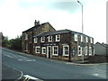
1
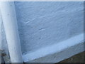
Ordnance Survey Cut Mark
The remains of this mark can be found on the wall of 88 Higher Reedley Road.
For more detail see : http://www.bench-marks.org.uk/bm45229
Image: © Peter Wood
Taken: 5 Sep 2012
0.11 miles
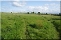
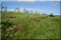
2

Open Space near Brierfield
Open Space favoured by dog walkers above Reedley, near Brierfield
Image: © Chris Heaton
Taken: 18 Jan 2011
0.13 miles
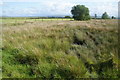
3
Pendle Way above Reedley
The long distance footpath crosses an area of rough ground, much favoured by dog walkers between Nelson Golf Course and Reedley.
Image: © Chris Heaton
Taken: 18 Jan 2011
0.14 miles
4
Paths onto open land
Former farmland above Brierfield now open to the public.
Image: © Bill Boaden
Taken: 16 Jun 2011
0.14 miles
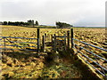
5
Former farmland on Marsden Height
The land is now open land enjoyed by the public with a network of paths, but it clearly used to be farmland which has been abandoned. It still has these remains of stiles, gates and fences marooned in the open space.
Image: © Bill Boaden
Taken: 16 Jun 2011
0.17 miles
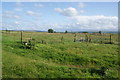
6
New plantation on Marsden Height
The land to the right is former farmland now used as open space, but people don't wander into the land on the left so much. It will soon be broad-leaved woodland.
Image: © Bill Boaden
Taken: 16 Jun 2011
0.18 miles
7
Pond on Marsden Height
The pond is marked on the 1:25,000 map, but it has almost completely grown over with moorland grass. There is still a lot of water hidden in here.
Image: © Bill Boaden
Taken: 16 Jun 2011
0.21 miles
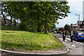
10
Marsden Cross, Higher Reedley Road, Brierfield
Image: © Alexander P Kapp
Taken: 5 Jun 2008
0.23 miles