IMAGES TAKEN NEAR TO
Bowness Avenue, NELSON, BB9 0SR
Introduction
This page details the photographs taken nearby to Bowness Avenue, BB9 0SR by members of the Geograph project.
The Geograph project started in 2005 with the aim of publishing, organising and preserving representative images for every square kilometre of Great Britain, Ireland and the Isle of Man.

There are currently over 7.5m images from over14,400 individuals and you can help contribute to the project by visiting https://www.geograph.org.uk
Image Map (Loading...)


Getting Data...Please wait
Leaflet Map data © OpenStreetMap
Images are licensed for reuse under creativecommons.org/licenses/by-sa/2.0
Notes
- Clicking on the map will re-center to the selected point.
- The higher the marker number, the further away the image location is from the centre of the postcode.
Image Listing (11 Images Found)
Images are licensed for reuse under creativecommons.org/licenses/by-sa/2.0
Image
Details
Distance
1
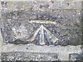
Ordnance Survey Cut Mark
This can be found on the garden wall of a house in Waidshouse Road.
For more detail see : http://www.bench-marks.org.uk/bm45224
Image: © Peter Wood
Taken: 5 Sep 2012
0.08 miles
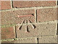
2
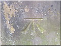
Ordnance Survey Cut Mark
This mark can be found on the garden wall of a house in Halifax Road.
For more detail see : http://www.bench-marks.org.uk/bm45225
Image: © Peter Wood
Taken: 5 Sep 2012
0.11 miles
5
Ordnance Survey Cut Mark
This mark can be found on the electricity sub-station in Beaufort Street.
For more detail see : http://www.bench-marks.org.uk/bm45223
Image: © Peter Wood
Taken: 5 Sep 2012
0.14 miles
7
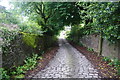
Scholefield Lane
A lane that was here long before the suburbs of Nelson swallowed up the surrounding area.
Image: © Bill Boaden
Taken: 16 Jun 2011
0.23 miles
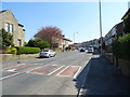
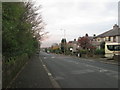
8
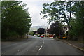
Halifax Road, Nelson
A cross Pennine route, here passing through some of the more affluent suburbs of Nelson. The trees accompany quite a long strip so it is generally darker than elsewhere. The ever dominant Pendle is behind in the distance.
Image: © Bill Boaden
Taken: 16 Jun 2011
0.23 miles
9
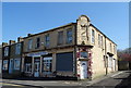
Launderette on Chapel House Road, Nelson
Former Nelson Cooperative building.
Image: © JThomas
Taken: 19 Apr 2019
0.24 miles
10
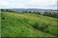
Quarry Hill
An open hillside in Nelson which has been retained as a local nature reserve.
Image: © Bill Boaden
Taken: 16 Jun 2011
0.25 miles