IMAGES TAKEN NEAR TO
Harrison Drive, COLNE, BB8 9SJ
Introduction
This page details the photographs taken nearby to Harrison Drive, BB8 9SJ by members of the Geograph project.
The Geograph project started in 2005 with the aim of publishing, organising and preserving representative images for every square kilometre of Great Britain, Ireland and the Isle of Man.

There are currently over 7.5m images from over14,400 individuals and you can help contribute to the project by visiting https://www.geograph.org.uk
Image Map
Images are licensed for reuse under creativecommons.org/licenses/by-sa/2.0
Notes
- Clicking on the map will re-center to the selected point.
- The higher the marker number, the further away the image location is from the centre of the postcode.
Image Listing (32 Images Found)
Images are licensed for reuse under creativecommons.org/licenses/by-sa/2.0
Image
Details
Distance
1
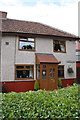
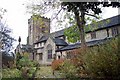
#97 Harrison Drive
There is an OS benchmark Image on the front of the house at the right hand corner near a small potted conifer
Image: © Roger Templeman
Taken: 10 Aug 2015
0.07 miles
2

Benchmark on #97 Harrison Drive
Ordnance Survey cut mark benchmark described on the Bench Mark Database at http://www.bench-marks.org.uk/bm69571
Image: © Roger Templeman
Taken: 10 Aug 2015
0.07 miles
3
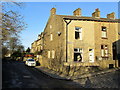
Dale Street, Colne
Dale Street off Haverholt Road, Colne
Image: © Chris Heaton
Taken: 30 Nov 2011
0.09 miles
4
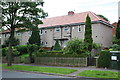
Houses on Harrison Drive
There is an OS benchmark Image on the front of the nearest house at its right hand corner
Image: © Roger Templeman
Taken: 10 Aug 2015
0.09 miles
5
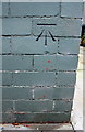
Benchmark on #37 Harrison Drive
Ordnance Survey cut mark benchmark described on the Bench Mark Database at http://www.bench-marks.org.uk/bm69570
Image: © Roger Templeman
Taken: 10 Aug 2015
0.09 miles
7
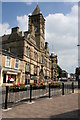
Colne Town Hall
Until 1974 Colne was a municipal borough but on local government reorganisation it lost its independent status and became part of the larger Pendle Borough. The Town Hall was built in 1894 and designed by Alfred Waterhouse, who was the architect for manchester Town Hall. It was opened on 13th jan 1894 by Samuel Catlow who went on to become the first mayor of Colne, when Colne achieved Borough status on 14th Sep 1895.
The building is part of the CBD and is a good example of urban functions and shows the former importance of these east Lancashire textile, with grand public buildings towns constructed from local mill stone grit.
Image: © John Tomlinson
Taken: 17 Aug 2005
0.10 miles
8
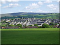
View over Colne, Lancashire, from Holt House
Image: © Dr Neil Clifton
Taken: 30 May 2005
0.10 miles
9
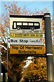
Top of Harrison Birtwistle
The location of this bus stop, at the top of Harrison Drive near the junction of Birtwistle Avenue, seems like an unintended tribute to Sir Harrison Birtwistle, born in nearby Accrington in 1934 and one of Britain's foremost modern composers.
Image: © Tiger
Taken: 16 Oct 2009
0.10 miles
10
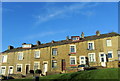
Row of Terraced Houses off Haverholt Road, Colne
Slanting row of terraced housing in Colne.
Image: © Chris Heaton
Taken: 30 Nov 2011
0.11 miles