
IMAGES TAKEN NEAR TO
Parker Street, COLNE, BB8 9QA
Introduction
This page details the photographs taken nearby to Parker Street, BB8 9QA by members of the Geograph project.
The Geograph project started in 2005 with the aim of publishing, organising and preserving representative images for every square kilometre of Great Britain, Ireland and the Isle of Man.

There are currently over 7.5m images from over14,400 individuals and you can help contribute to the project by visiting https://www.geograph.org.uk
Image Map
Images are licensed for reuse under creativecommons.org/licenses/by-sa/2.0
Notes
- Clicking on the map will re-center to the selected point.
- The higher the marker number, the further away the image location is from the centre of the postcode.
Image Listing (44 Images Found)
Images are licensed for reuse under creativecommons.org/licenses/by-sa/2.0
Image
Details
Distance
1
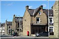
Terraced streets, Colne
Colne is a town of many stone built terraced streets. These are on the west side of town with the end of Parker Street in the foreground. The business is a hair stylists named 'Chocolate'.
Image: © Gordon Hatton
Taken: 5 Apr 2018
0.01 miles
2
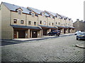
New housing on Alkincoates Road, Colne
Image: © Alexander P Kapp
Taken: 22 Jul 2007
0.08 miles
3

Bridge taking Barrowford Road (B6247) over dismantled railway
There is an Ordnance Survey benchmark Image on the near end of the parapet which is at the Heirshouse Lane junction
Image: © Roger Templeman
Taken: 8 Apr 2025
0.10 miles
4
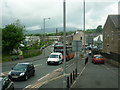
Windsor Street, Colne
Taken from the 872 Skipton-bound bus, this is Windsor Street, Colne, which can be seen running into North Valley Road. A cloud-capped Pendle Hill dominates from a distance.
Image: © Carroll Pierce
Taken: 16 Jun 2013
0.12 miles
5

Benchmark on north parapet of Barrowford Road bridge
Ordnance Survey cut mark benchmark levelled at 158.935m above Newlyn Datum verified 1961
Image: © Roger Templeman
Taken: 8 Apr 2025
0.12 miles
6
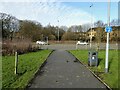
Former route of Colne to Skipton railway
This modern road Vivary Way did not exist when the railway came this way and must be a major obstacle to the re-opening campaign. In the trees beyond this Colne bypass is a substantial bridge carrying Barrowford Road over the railway of six lines at that point.
Image: © Kevin Waterhouse
Taken: 6 Feb 2023
0.13 miles
7
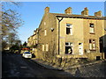
Dale Street, Colne
Dale Street off Haverholt Road, Colne
Image: © Chris Heaton
Taken: 30 Nov 2011
0.14 miles
9
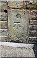
Benchmark on #45 Lord Street
Ordnance Survey cut mark benchmark described on the Bench Mark Database at http://www.bench-marks.org.uk/bm46547
Image: © Roger Templeman
Taken: 10 Aug 2015
0.17 miles
10
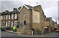
Junction of Lord Street / North Valley Road
There is an OS benchmark Image on a stone in the wall outside the house on the corner, left of the traffic light pole
Image: © Roger Templeman
Taken: 10 Aug 2015
0.17 miles