IMAGES TAKEN NEAR TO
Greenfield Road, COLNE, BB8 9PF
Introduction
This page details the photographs taken nearby to Greenfield Road, BB8 9PF by members of the Geograph project.
The Geograph project started in 2005 with the aim of publishing, organising and preserving representative images for every square kilometre of Great Britain, Ireland and the Isle of Man.

There are currently over 7.5m images from over14,400 individuals and you can help contribute to the project by visiting https://www.geograph.org.uk
Image Map
Images are licensed for reuse under creativecommons.org/licenses/by-sa/2.0
Notes
- Clicking on the map will re-center to the selected point.
- The higher the marker number, the further away the image location is from the centre of the postcode.
Image Listing (154 Images Found)
Images are licensed for reuse under creativecommons.org/licenses/by-sa/2.0
Image
Details
Distance
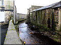
1
Colne Water
With Greenfield Mill on the right and Bridge Mill on the left, the building with the red and grey top is Primet Business Centre
Image: © Alexander P Kapp
Taken: 22 Jan 2008
0.01 miles
2
Colne Water
Looking downstream and taken from the same point as Image
Image: © Dr Neil Clifton
Taken: 9 Feb 2010
0.01 miles
3
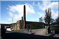
Colne: Greenfield Mill
A former textile mill which has found alternative use as a bespoke furniture centre. It is just off the A56 on the north side, a little way beyond the railway viaduct if coming from Colne.
Image: © Dr Neil Clifton
Taken: 9 Feb 2010
0.02 miles
4
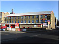
Colne Snooker Club
At the east end of Burnley Road. A former textile mill has been found new uses, bring shared between the snooker club and a storage centre.
Image: © Dr Neil Clifton
Taken: 11 Feb 2010
0.02 miles
5
Colne: Greenfield Mill
Seen from the end of Knotts Lane
Image: © Dr Neil Clifton
Taken: 19 Mar 2010
0.02 miles
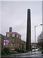
6
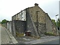
Greenfield Mill, Colne - datestone
This complex of industrial buildings is grade II listed (list entry 1378740), described as 'Former textile loom manufactory, foundry and textile mill'. This end of the site is newer, as it has a datestone of 1956.
Image: © Stephen Craven
Taken: 23 Aug 2022
0.03 miles
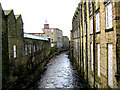
7
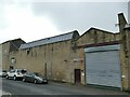
Greenfield Mill, Colne - courtyard
This complex of industrial buildings is grade II listed (list entry 1378740), described as 'Former textile loom manufactory, foundry and textile mill'. This end of the site was the Primet iron foundry and still looks to be in industrial use.
Image: © Stephen Craven
Taken: 23 Aug 2022
0.03 miles
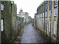
8
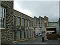
Buttressed houses on Bankfield Street
It isn't usual for terraced houses, even those built on a slope, to need buttresses. Either these houses were built badly, or on poor soil, or maybe there was one more house that's been demolished. Image shows a side view.
Image: © Stephen Craven
Taken: 23 Aug 2022
0.04 miles
10
Colne Water from Primet Bridge
Looking downstream. Greenfield Mill is on the right.
Image: © Dr Neil Clifton
Taken: 9 Feb 2010
0.04 miles