IMAGES TAKEN NEAR TO
Bolton Street, COLNE, BB8 9NR
Introduction
This page details the photographs taken nearby to Bolton Street, BB8 9NR by members of the Geograph project.
The Geograph project started in 2005 with the aim of publishing, organising and preserving representative images for every square kilometre of Great Britain, Ireland and the Isle of Man.

There are currently over 7.5m images from over14,400 individuals and you can help contribute to the project by visiting https://www.geograph.org.uk
Image Map
Images are licensed for reuse under creativecommons.org/licenses/by-sa/2.0
Notes
- Clicking on the map will re-center to the selected point.
- The higher the marker number, the further away the image location is from the centre of the postcode.
Image Listing (176 Images Found)
Images are licensed for reuse under creativecommons.org/licenses/by-sa/2.0
Image
Details
Distance
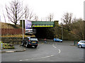
1
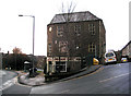
Colne: Lancashire Carpet Centre
This building is immediately visible on the A56 after passing through the railway viaduct at Colne station. The road going up to the right is Leach Street.
Image: © Dr Neil Clifton
Taken: 9 Feb 2010
0.02 miles
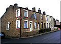
2
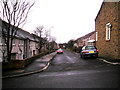
Colne: Bolton Street
This street of mostly post-WWII housing, runs west from the bottom of Leach Street.
Image: © Dr Neil Clifton
Taken: 9 Feb 2010
0.02 miles
3
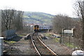
The SELRAP Special approaching Colne, Lancashire
The two Class 156 diesel units seen approaching Colne station across the viaduct will form a special train from Colne to Skipton, the first for 37 years! This event was organised by the Skipton and East Lancs Rail Action Partnership to draw attention to their campaign to have the missing railway link between Colne and Skipton re-instated. Needless to say, the train had to travel by a very circuitous route via Blackburn and Hellifield.
Image: © Dr Neil Clifton
Taken: 1 Apr 2007
0.03 miles
5
Colne: Leach Street, Nos 1 to 9
Very probably these houses were built with a view to accommodating employees at the nearby Greenfield Mill
Image: © Dr Neil Clifton
Taken: 9 Feb 2010
0.03 miles
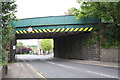
6
Colne: Railway bridge over Primet Hill
Seen from the southwest
Image: © Dr Neil Clifton
Taken: 9 Feb 2010
0.03 miles
7
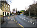
Colne: Looking up Primet Hill
The road is part of the A56, looking towards central Colne. Lancashire Carpet Company on the left. Railway viaduct leads, on the left, to a dead end at Colne station, where the trackbed of the link thence to Skipton remains derelict.
Image: © Dr Neil Clifton
Taken: 9 Feb 2010
0.04 miles
8
Railway Bridge GJC 27m32ch, Primet Hill
There is an OS benchmark Image at the junction of the right hand side bridge wall and the roadside wall.
Image: © Roger Templeman
Taken: 10 Aug 2015
0.04 miles
9
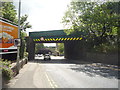
Railway bridge over Primet Hill (A56)
Just down from Colne Railway Station.
Image: © JThomas
Taken: 2 Aug 2018
0.04 miles
10
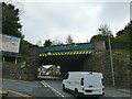
Railway bridge, Primet Hill, Colne
The bridge once carried four tracks into Colne station, of which only one remains.
Image: © Stephen Craven
Taken: 23 Aug 2022
0.04 miles