IMAGES TAKEN NEAR TO
Princess Street, COLNE, BB8 9AN
Introduction
This page details the photographs taken nearby to Princess Street, BB8 9AN by members of the Geograph project.
The Geograph project started in 2005 with the aim of publishing, organising and preserving representative images for every square kilometre of Great Britain, Ireland and the Isle of Man.

There are currently over 7.5m images from over14,400 individuals and you can help contribute to the project by visiting https://www.geograph.org.uk
Image Map
Images are licensed for reuse under creativecommons.org/licenses/by-sa/2.0
Notes
- Clicking on the map will re-center to the selected point.
- The higher the marker number, the further away the image location is from the centre of the postcode.
Image Listing (170 Images Found)
Images are licensed for reuse under creativecommons.org/licenses/by-sa/2.0
Image
Details
Distance
1
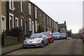
Princess Street, Colne
Steep cobbled street leading south off Rigby Street.
Image: © Stephen McKay
Taken: 23 Nov 2015
0.01 miles
2
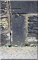
Junction of Lord Street / North Valley Road
There is an OS benchmark Image on a stone in the wall outside the house on the corner, left of the traffic light pole
Image: © Roger Templeman
Taken: 10 Aug 2015
0.03 miles
3
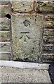
Benchmark on #45 Lord Street
Ordnance Survey cut mark benchmark described on the Bench Mark Database at http://www.bench-marks.org.uk/bm46547
Image: © Roger Templeman
Taken: 10 Aug 2015
0.04 miles
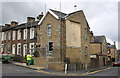
4
Lord Street Primary School
This looks like a late Victorian building in an area of streets of a similar age.
Image: © Gordon Hatton
Taken: 5 Apr 2018
0.04 miles
5
Benchmark on #4 Queen Street
Ordnance Survey cut mark benchmark described on the Bench Mark Database at http://www.bench-marks.org.uk/bm46954
Image: © Roger Templeman
Taken: 10 Aug 2015
0.05 miles
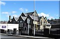
6
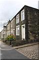
Houses on Queen Street
There is an OS benchmark Image at the junction of the nearest house with its front garden wall
Image: © Roger Templeman
Taken: 10 Aug 2015
0.05 miles
8
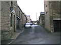
Colne: Back Brown Street
Running east from Guysyke. Hartley's Funeral Parlour is on the right.
Image: © Dr Neil Clifton
Taken: 9 Feb 2010
0.06 miles
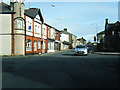
9
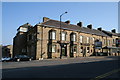
Crown Hotel, Albert Road, Colne, Lancashire
The 'Crown' adjoins Colne railway station, (a bus shelter at the end of a long single track from Burnley), and the user of public transport wishing to go to Skipton must change here to a bus, provided once an hour by Pennine Motors since the early 1990s. Prior to that it was necessary to change at Barnoldswick. Many years ago, the train would have taken him all the way to Skipton.
Note added, November 2013: In the last couple of years, Transdev, the operator of Burnley & Pendle buses, have extended their No.28 service through to Skipton on a regular basis, (daytime only) providing a much better link to the popular Yorkshire market town.
Image: © Dr Neil Clifton
Taken: 1 Apr 2007
0.07 miles
10
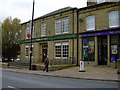
The Old Police Station, Albert Road, Colne
Now Tubbs china shop
Image: © Robert Wade
Taken: 28 Oct 2009
0.07 miles