IMAGES TAKEN NEAR TO
Hollin Hall, COLNE, BB8 8QE
Introduction
This page details the photographs taken nearby to Hollin Hall, BB8 8QE by members of the Geograph project.
The Geograph project started in 2005 with the aim of publishing, organising and preserving representative images for every square kilometre of Great Britain, Ireland and the Isle of Man.

There are currently over 7.5m images from over14,400 individuals and you can help contribute to the project by visiting https://www.geograph.org.uk
Image Map
Images are licensed for reuse under creativecommons.org/licenses/by-sa/2.0
Notes
- Clicking on the map will re-center to the selected point.
- The higher the marker number, the further away the image location is from the centre of the postcode.
Image Listing (16 Images Found)
Images are licensed for reuse under creativecommons.org/licenses/by-sa/2.0
Image
Details
Distance
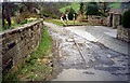
2
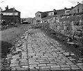
Trawden tram terminus (2)
See Image A view from the opposite direction of the fragment of tram rail remaining some 55 years after tram services to Trawden ceased.
Image: © Dr Neil Clifton
Taken: 23 Apr 1983
0.20 miles
3
Trawden tram terminus
See Image At the upper end of the Traden private right of way, where the trams terminated, a small fragment of rail still remained in 1983, some 55 years after the last tram had run to Trawden.
Image: © Dr Neil Clifton
Taken: 23 Apr 1983
0.21 miles
4
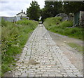
Disused Tram Track Trawden
A few feet of the iron rails remain at the top of the hill
Image: © Robert Wade
Taken: 23 Jun 2007
0.21 miles
5
The last remains of Colne Corporation Light Railways
The tram line to Trawden was abandoned in 1935 but over 60 years later this fragment of track remained at Trawden terminus
Image: © Dr Neil Clifton
Taken: Unknown
0.21 miles
6
The last remains of Colne Corporation Light Railways
See Image
Image: © Dr Neil Clifton
Taken: Unknown
0.21 miles
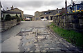
7
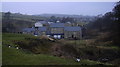
White Lees Avenue
The disused tramway is to the right of this photograph.
Image: © Robert Wade
Taken: 6 Jul 2008
0.22 miles
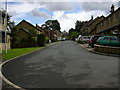
8
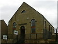
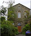
Zion Chapel
Since I last photographed this chapel the work to convert it into two dwellings has been completed. If you think you recognise it you may have seen it in the BBC series "Homes Under the Hammer".
Image: © Robert Wade
Taken: 6 Jul 2008
0.22 miles
9
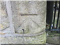
Ordnance Survey Cut Mark
This mark can be found on a house wall in Lane House Lane.
For more detail see : http://www.bench-marks.org.uk/bm43617
Image: © Peter Wood
Taken: 23 Jun 2012
0.22 miles