IMAGES TAKEN NEAR TO
Keighley Road, COLNE, BB8 8NL
Introduction
This page details the photographs taken nearby to Keighley Road, BB8 8NL by members of the Geograph project.
The Geograph project started in 2005 with the aim of publishing, organising and preserving representative images for every square kilometre of Great Britain, Ireland and the Isle of Man.

There are currently over 7.5m images from over14,400 individuals and you can help contribute to the project by visiting https://www.geograph.org.uk
Image Map
Images are licensed for reuse under creativecommons.org/licenses/by-sa/2.0
Notes
- Clicking on the map will re-center to the selected point.
- The higher the marker number, the further away the image location is from the centre of the postcode.
Image Listing (14 Images Found)
Images are licensed for reuse under creativecommons.org/licenses/by-sa/2.0
Image
Details
Distance
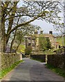
2
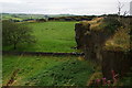
Bough Gap Farm
Viewed from Keighley Road which comes from Laneshaw Bridge.
Image: © Bill Boaden
Taken: 29 Aug 2011
0.01 miles
3
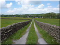
Footpath from Winewall to Bough Gap Farm
Image: © Alexander P Kapp
Taken: 2 Jun 2010
0.07 miles
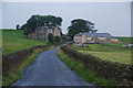
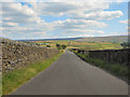
4
Keighley Road north east of Bough Gap Farm
Image: © Alexander P Kapp
Taken: 2 Jun 2010
0.11 miles
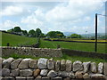
5
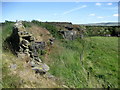
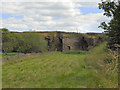
Disused Quarry, Winewall
Found behind Hill Top Farm, Winewall.
Image: © Chris Heaton
Taken: 29 Jun 2010
0.15 miles
8
Footpath towards Wycoller
There is low cloud on Boulsworth Hill.
Image: © Bill Boaden
Taken: 29 Aug 2011
0.20 miles
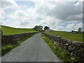
10
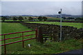
Lane Top
Lane Top between Winewall and Trawden
Image: © David Dixon
Taken: 30 Jul 2011
0.22 miles