IMAGES TAKEN NEAR TO
Noyna Road, COLNE, BB8 7QN
Introduction
This page details the photographs taken nearby to Noyna Road, BB8 7QN by members of the Geograph project.
The Geograph project started in 2005 with the aim of publishing, organising and preserving representative images for every square kilometre of Great Britain, Ireland and the Isle of Man.

There are currently over 7.5m images from over14,400 individuals and you can help contribute to the project by visiting https://www.geograph.org.uk
Image Map
Images are licensed for reuse under creativecommons.org/licenses/by-sa/2.0
Notes
- Clicking on the map will re-center to the selected point.
- The higher the marker number, the further away the image location is from the centre of the postcode.
Image Listing (6 Images Found)
Images are licensed for reuse under creativecommons.org/licenses/by-sa/2.0
Image
Details
Distance
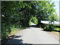
1
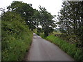
Lane near Noyna Bottom, Foulridge, Lancashire
Noyna Lane is typical of the narrow lanes in this part of Lancashire. Passing places are very few, and if you meet a car coming on the opposite direction, one of you must reverse, possibly several hundred yards, to find a field gate or somewhere else where one of the cars can get out of the way.
Image: © Dr Neil Clifton
Taken: 26 Jun 2006
0.13 miles
3
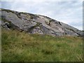
Noyna Rocks closeup
Image: © Derek Haslam
Taken: 7 Aug 2013
0.22 miles
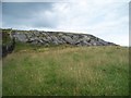
4
Noyna Rocks
Image: © Derek Haslam
Taken: 7 Aug 2013
0.22 miles
5
Noyna Road near Higher Broach
Looking eastward.
Image: © Peter Wood
Taken: 17 Jul 2017
0.25 miles
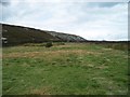
6
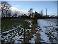
Approaching White House
Following a footpath through fields towards White House, while walking between Laneshaw Bridge to Foulridge.
Image: © Chris Heaton
Taken: 11 Feb 2009
0.25 miles