IMAGES TAKEN NEAR TO
Foulridge, COLNE, BB8 7QH
Introduction
This page details the photographs taken nearby to BB8 7QH by members of the Geograph project.
The Geograph project started in 2005 with the aim of publishing, organising and preserving representative images for every square kilometre of Great Britain, Ireland and the Isle of Man.

There are currently over 7.5m images from over14,400 individuals and you can help contribute to the project by visiting https://www.geograph.org.uk
Image Map
Images are licensed for reuse under creativecommons.org/licenses/by-sa/2.0
Notes
- Clicking on the map will re-center to the selected point.
- The higher the marker number, the further away the image location is from the centre of the postcode.
Image Listing (6 Images Found)
Images are licensed for reuse under creativecommons.org/licenses/by-sa/2.0
Image
Details
Distance
1
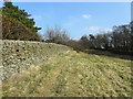
Footpath leading towards Kelbrook Wood
Not as tranquil as it seems, for there is a constant noise of gunfire issuing from the woods - one just hopes the weapons are not aimed in your direction if you happen to be following this footpath beside the wall.
Image: © Chris Heaton
Taken: 23 Mar 2011
0.10 miles
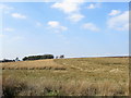
2
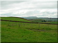
Fields east of Great Edge Farm
With Pendle Hill in the background.
Image: © John Topping
Taken: 4 Sep 2011
0.12 miles
3
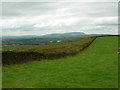
Wall on Great Edge
Foulridge reservoir can be seen in the middle distance and Pendle Hill behind.
Image: © John Topping
Taken: 4 Sep 2011
0.20 miles
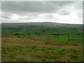
5
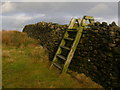
Kelbrook Moor
The moor seen from the footpath near Kelbrook Wood
Image: © Chris Heaton
Taken: 23 Mar 2011
0.22 miles
6
Great Edge
View SSE towards The Forest of Trawden and Boulsworth Hill.
Image: © John Topping
Taken: 4 Sep 2011
0.25 miles