IMAGES TAKEN NEAR TO
Skipton Old Road, COLNE, BB8 7QG
Introduction
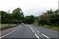
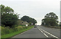
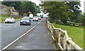
This page details the photographs taken nearby to Skipton Old Road, BB8 7QG by members of the Geograph project.
The Geograph project started in 2005 with the aim of publishing, organising and preserving representative images for every square kilometre of Great Britain, Ireland and the Isle of Man.

There are currently over 7.5m images from over14,400 individuals and you can help contribute to the project by visiting https://www.geograph.org.uk
Image Map
Images are licensed for reuse under creativecommons.org/licenses/by-sa/2.0
Notes
- Clicking on the map will re-center to the selected point.
- The higher the marker number, the further away the image location is from the centre of the postcode.
Image Listing (6 Images Found)
Images are licensed for reuse under creativecommons.org/licenses/by-sa/2.0
Image
Details
Distance
3
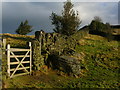
The way to Noyna Hill
Gate in dry-stone wall.
Image: © John H Darch
Taken: 8 Jan 2011
0.13 miles
5
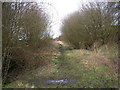
Disused railway
The trackbed of the Skipton to Colne line north of Foulridge.
Image: © John Illingworth
Taken: 29 Mar 2006
0.21 miles
6
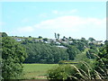
Foulridge village, near Burnley
A much nicer village than its name suggests! It is actually pronounced 'foalridge' and it's a name, like others in the area, which stems from Viking times.
Image: © David Medcalf
Taken: 16 Jul 2005
0.24 miles