IMAGES TAKEN NEAR TO
Barnoldswick Road, COLNE, BB8 7NA
Introduction
This page details the photographs taken nearby to Barnoldswick Road, BB8 7NA by members of the Geograph project.
The Geograph project started in 2005 with the aim of publishing, organising and preserving representative images for every square kilometre of Great Britain, Ireland and the Isle of Man.

There are currently over 7.5m images from over14,400 individuals and you can help contribute to the project by visiting https://www.geograph.org.uk
Image Map
Images are licensed for reuse under creativecommons.org/licenses/by-sa/2.0
Notes
- Clicking on the map will re-center to the selected point.
- The higher the marker number, the further away the image location is from the centre of the postcode.
Image Listing (8 Images Found)
Images are licensed for reuse under creativecommons.org/licenses/by-sa/2.0
Image
Details
Distance
1
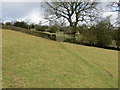
Field footpath approaching a wall stile and gateway
Looking north-eastward.
Image: © Peter Wood
Taken: 10 Mar 2019
0.06 miles
2
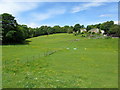
Holly Bush Farm
The farm seen across meadows from the northern tip of Slipper Hill Reservoir
Image: © Chris Heaton
Taken: 25 May 2011
0.12 miles
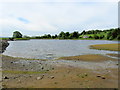
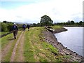
3

Slipper Hill Reservoir
The water level in this reservoir is more than 2 metres below normal. The reservoir is used to supply water to the Leeds-Liverpool Canal, maintaining the water levels when the locks operate. The canal has been closed to navigation in the Summer of 2010 due to the lack of water.
Image: © Chris Tomlinson
Taken: 18 Aug 2010
0.12 miles
4
Slipper Hill Reservoir
Small reservoir which was constructed to help maintain water levels in the nearby Leeds/Liverpool Canal
Image: © Chris Heaton
Taken: 25 May 2011
0.13 miles
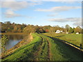
5
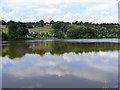
Slipper Hill Reservoir, near Foulridge
The fullest and the prettiest of the reservoirs feeding the L&L Canal.
Image: © Allan Friswell
Taken: 14 Jul 2009
0.13 miles
8
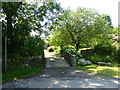
Bridge over Slipper Hill Clough
The waymarker shows the public right of way over the bridge between housing
Image: © Raymond Knapman
Taken: 11 Jun 2018
0.22 miles