
IMAGES TAKEN NEAR TO
Red Lane, COLNE, BB8 7JR
Introduction
This page details the photographs taken nearby to Red Lane, BB8 7JR by members of the Geograph project.
The Geograph project started in 2005 with the aim of publishing, organising and preserving representative images for every square kilometre of Great Britain, Ireland and the Isle of Man.

There are currently over 7.5m images from over14,400 individuals and you can help contribute to the project by visiting https://www.geograph.org.uk
Image Map
Images are licensed for reuse under creativecommons.org/licenses/by-sa/2.0
Notes
- Clicking on the map will re-center to the selected point.
- The higher the marker number, the further away the image location is from the centre of the postcode.
Image Listing (4 Images Found)
Images are licensed for reuse under creativecommons.org/licenses/by-sa/2.0
Image
Details
Distance
1
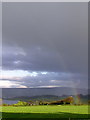
Rainbow over Lake Burwain
Lake Burwain - or more accurately, Foulridge Lower Reservoir - was built in the 18th century to provide water for the Leeds & Liverpool canal. Today it is also the home of a sailing club.
Image: © Heather Sheldrick
Taken: 13 May 2005
0.16 miles
2
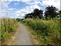
Colne Edge
Walked up into Alkincoates Woodland local nature reserve. Top looks like path after Derek's Orchard stone or actually in Derek's Orchard which was rather overgrown today. Derek's Orchard is on the right of the path in this view.
Name: Colne Edge
Hill number: 108774
Height: 222m / 728ft
Area: 36: Lancashire, Cheshire & the Southern Pennines
Class: 2
Grid ref: SD882412 (est)
Drop: 34m
Col: 188m
Image: © Rude Health
Taken: 2 Aug 2013
0.18 miles
3

Junction of former footpath through Dereks Orchard with Red Lane
Ordnance Survey records indicate that a benchmark was levelled in 1956 at 219.837m above Newlyn Datum on the near end of the stone wall
Image: © Roger Templeman
Taken: 19 May 2025
0.19 miles
4
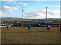
Colne FC v Ramsbottom Utd
This is a lovely ground in a hilltop position, and you can't help looking at the expanse of hills. The ground is not entirely level.
Image: © Bill Boaden
Taken: 18 Feb 2006
0.21 miles