IMAGES TAKEN NEAR TO
Emmott Lane, COLNE, BB8 7JE
Introduction
This page details the photographs taken nearby to Emmott Lane, BB8 7JE by members of the Geograph project.
The Geograph project started in 2005 with the aim of publishing, organising and preserving representative images for every square kilometre of Great Britain, Ireland and the Isle of Man.

There are currently over 7.5m images from over14,400 individuals and you can help contribute to the project by visiting https://www.geograph.org.uk
Image Map
Images are licensed for reuse under creativecommons.org/licenses/by-sa/2.0
Notes
- Clicking on the map will re-center to the selected point.
- The higher the marker number, the further away the image location is from the centre of the postcode.
Image Listing (42 Images Found)
Images are licensed for reuse under creativecommons.org/licenses/by-sa/2.0
Image
Details
Distance
1
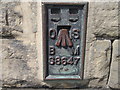
Ordnance Survey Flush Bracket S8647
This bracket can be found on a wall of Laneshaw Bridge School.
For more detail see : http://www.bench-marks.org.uk/bm11088
Image: © Peter Wood
Taken: 30 Apr 2012
0.03 miles
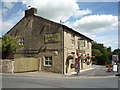
3
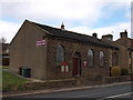
Wesleyan Methodist Chapel Laneshaw Bridge
Located on Keighley Road near the junction with Emmott Lane, the date stone on this building is 1858 and was still in use when this image was taken.
Image: © Steve Houldsworth
Taken: 27 Mar 2010
0.07 miles
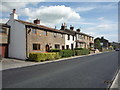
5
Laneshaw Bridge
Keighley Road from Covey Bridge
Image: © Kevin Rushton
Taken: 3 May 2008
0.08 miles
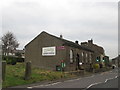
8
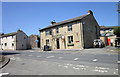
The Emmott Arms at Laneshaw Bridge
On Keighlay Road.
Image: © JThomas
Taken: 11 Aug 2018
0.09 miles
9
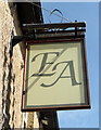
Sign for the Emmott Arms at Laneshaw Bridge
Image: © JThomas
Taken: 11 Aug 2018
0.09 miles
10
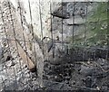
Ordnance Survey Cut Mark
This OS cut mark can be found on the house west side of Emmott Lane. It marks a point 463.4ft above mean sea level.
Image: © Adrian Dust
Taken: 18 Jun 2021
0.09 miles