IMAGES TAKEN NEAR TO
Emmott Lane, COLNE, BB8 7EG
Introduction
This page details the photographs taken nearby to Emmott Lane, BB8 7EG by members of the Geograph project.
The Geograph project started in 2005 with the aim of publishing, organising and preserving representative images for every square kilometre of Great Britain, Ireland and the Isle of Man.

There are currently over 7.5m images from over14,400 individuals and you can help contribute to the project by visiting https://www.geograph.org.uk
Image Map
Images are licensed for reuse under creativecommons.org/licenses/by-sa/2.0
Notes
- Clicking on the map will re-center to the selected point.
- The higher the marker number, the further away the image location is from the centre of the postcode.
Image Listing (14 Images Found)
Images are licensed for reuse under creativecommons.org/licenses/by-sa/2.0
Image
Details
Distance
1
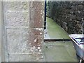
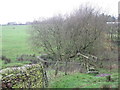
Ordnance Survey Cut Mark
This mark can be found on the wall of Cliffe Cottage (a private dwelling) at Lane Head.
The recorded details give a height of 229.5519 metres above sea level.
For more detail see : https://www.bench-marks.org.uk/bm66174
Image: © Peter Wood
Taken: 20 Apr 2022
0.07 miles
2
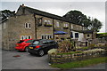
Alma Inn, Laneshaw Bridge
It used to be a traditional pub but has been transformed into a restaurant. It has a large car park and its advertising boards are seen on many local roads. It did have a couple of good beers.
Image: © Bill Boaden
Taken: 29 Aug 2011
0.11 miles
3
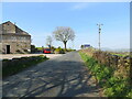
Hill Lane at The Alma Inn, Laneshawbridge
Looking south-westward.
Image: © Peter Wood
Taken: 20 Apr 2022
0.13 miles
4
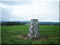
Lower Hill Trig Pillar (239 metres)
This pillar is in a field on the line of a public footpath behind The Alma public house. Pendle Hill, with its summit in cloud, is somewhere on the skyline.
Image: © michael ely
Taken: 4 Oct 2006
0.14 miles
5
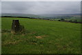
Trig point on Lower Hill
In the distance is the Wycoller valley with Boulsworth Hill to the right.
Image: © Bill Boaden
Taken: 29 Aug 2011
0.15 miles
6
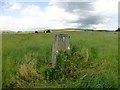
Law Hill
I was going to save this one for my 2,000th TuMP due to being so close to the pub. Parked in gateway then short walk to trig then climbed to true hill top. Field rather overgrown at the moment. This was my 2050th TuMP.
Name: Law Hill
Hill number: 108749
Height: 240m / 787ft
Area: 36: Lancashire, Cheshire & the Southern Pennines
Class: 2
Grid ref: SD914410 (est)
Drop: 30m
Col: 210m
Image: © Rude Health
Taken: 2 Aug 2013
0.16 miles

9
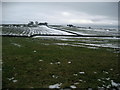
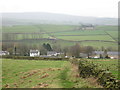
View towards Lower Hill
Winter scene looking due south from the road outside Far Salter Syke Farm.
Image: © Chris Heaton
Taken: 11 Feb 2009
0.17 miles