IMAGES TAKEN NEAR TO
BB8 5TN
Introduction
This page details the photographs taken nearby to BB8 5TN by members of the Geograph project.
The Geograph project started in 2005 with the aim of publishing, organising and preserving representative images for every square kilometre of Great Britain, Ireland and the Isle of Man.

There are currently over 7.5m images from over14,400 individuals and you can help contribute to the project by visiting https://www.geograph.org.uk
Image Map
Images are licensed for reuse under creativecommons.org/licenses/by-sa/2.0
Notes
- Clicking on the map will re-center to the selected point.
- The higher the marker number, the further away the image location is from the centre of the postcode.
Image Listing (72 Images Found)
Images are licensed for reuse under creativecommons.org/licenses/by-sa/2.0
Image
Details
Distance
9
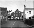
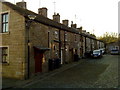
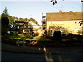
Salterforth village, Yorkshire
This is the view you will get as you turn off the main Barnoldswick to Kelbrook road (B6383) into the village. And you had better drive carefully, too: the roads are narrow and twisty. In fact the new B6383 cuts through Salterforth in a very unkind way, leaving most of the village on one side but the pub (the Anchor) on the other.
Image: © Dr Neil Clifton
Taken: 5 Dec 1982
0.10 miles