IMAGES TAKEN NEAR TO
Blucher Street, COLNE, BB8 0HQ
Introduction
This page details the photographs taken nearby to Blucher Street, BB8 0HQ by members of the Geograph project.
The Geograph project started in 2005 with the aim of publishing, organising and preserving representative images for every square kilometre of Great Britain, Ireland and the Isle of Man.

There are currently over 7.5m images from over14,400 individuals and you can help contribute to the project by visiting https://www.geograph.org.uk
Image Map
Images are licensed for reuse under creativecommons.org/licenses/by-sa/2.0
Notes
- Clicking on the map will re-center to the selected point.
- The higher the marker number, the further away the image location is from the centre of the postcode.
Image Listing (235 Images Found)
Images are licensed for reuse under creativecommons.org/licenses/by-sa/2.0
Image
Details
Distance
1
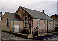
Blucher St Independent Methodist Colne
The original church was founded in 1884 and closed before 2002, when this image was taken the building was used by the New Life Christian Centre.
Image: © Steve Houldsworth
Taken: 27 Feb 2011
0.03 miles
2
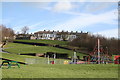
Children's Playground, Waterside, Colne
The old notorious Waterside area, a maze of small factories and mostly slum dwellings, was razed many years ago - partly before and partly after the Second World War. The outlines of some of the buildings were left and still remain, but most of the area was grassed, and a playground provided, as seen here. The eleven terrace houses whose backs are seen in the distance are in Essex Street. Colne is an ancient town well worth a visit, with much to offer the tourist and the photographer.
Image: © Dr Neil Clifton
Taken: 14 Feb 2007
0.06 miles
3
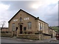
New Life Christian Centre Colne
Located at the junction of Midgley Street and West Street, the building has a date stone AD 1877; it is not clear what church occupied this prior to the New Life Christian Centre who occupied the building when this image was taken.
Image: © Steve Houldsworth
Taken: 26 May 2011
0.06 miles
4
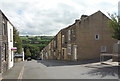
Broken Banks, Colne
A terrace of houses on a steep slope.
Image: © JThomas
Taken: 2 Aug 2018
0.08 miles
5
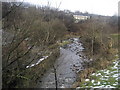
Above Colne Water
Following a path beside Colne Water between Waterside and Carry Bridge.
Image: © Chris Heaton
Taken: 11 Feb 2009
0.09 miles
6

Disused building by Colne Water
On the north side of Colne Water and east of Waterside Bridge a large fellmongery was once situated. Such establishments were no place for the squeamish. This semi-derelict building may have been part of it.
Image: © Dr Neil Clifton
Taken: 4 Oct 2007
0.10 miles
7
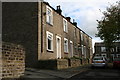
Lune Street, Colne, Lancashire
This shows numbers 3 to 13 Lune Street. There is no No 1. At the far end, Lune Street forms a T-junction with Midgley Street.
Image: © Dr Neil Clifton
Taken: 4 Oct 2007
0.10 miles
8

Colne Water, Lancashire
The disused buildings on the far bank of the river may have been part of the fellmongery that once existed here.
Image: © Dr Neil Clifton
Taken: 4 Oct 2007
0.10 miles
9
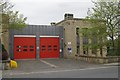
Colne fire station
Colne fire station, Craddock Road, Colne, Lancashire
Image: © Kevin Hale
Taken: 4 Jun 2009
0.10 miles
10
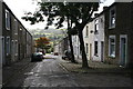
Midgley Street, Colne, Lancashire
The houses on the right-hand side are the even numbers from 2 (this end) to 40 (far end). The street runs steeply downhill.
Image: © Dr Neil Clifton
Taken: 4 Oct 2007
0.10 miles