IMAGES TAKEN NEAR TO
Clayton Street, COLNE, BB8 0HJ
Introduction
This page details the photographs taken nearby to Clayton Street, BB8 0HJ by members of the Geograph project.
The Geograph project started in 2005 with the aim of publishing, organising and preserving representative images for every square kilometre of Great Britain, Ireland and the Isle of Man.

There are currently over 7.5m images from over14,400 individuals and you can help contribute to the project by visiting https://www.geograph.org.uk
Image Map
Images are licensed for reuse under creativecommons.org/licenses/by-sa/2.0
Notes
- Clicking on the map will re-center to the selected point.
- The higher the marker number, the further away the image location is from the centre of the postcode.
Image Listing (216 Images Found)
Images are licensed for reuse under creativecommons.org/licenses/by-sa/2.0
Image
Details
Distance
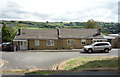
1
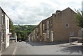
Broken Banks, Colne
A terrace of houses on a steep slope.
Image: © JThomas
Taken: 2 Aug 2018
0.04 miles
2
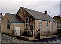
Blucher St Independent Methodist Colne
The original church was founded in 1884 and closed before 2002, when this image was taken the building was used by the New Life Christian Centre.
Image: © Steve Houldsworth
Taken: 27 Feb 2011
0.05 miles
3
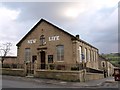
New Life Christian Centre Colne
Located at the junction of Midgley Street and West Street, the building has a date stone AD 1877; it is not clear what church occupied this prior to the New Life Christian Centre who occupied the building when this image was taken.
Image: © Steve Houldsworth
Taken: 26 May 2011
0.08 miles
4
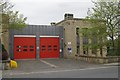
Colne fire station
Colne fire station, Craddock Road, Colne, Lancashire
Image: © Kevin Hale
Taken: 4 Jun 2009
0.08 miles
6
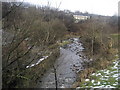
Above Colne Water
Following a path beside Colne Water between Waterside and Carry Bridge.
Image: © Chris Heaton
Taken: 11 Feb 2009
0.09 miles
7
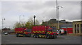
Colne Fire Station, Craddock Road
The two incident vehicles are parked in the bus station
Image: © Robert Wade
Taken: 28 Oct 2009
0.09 miles
8
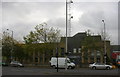
Colne Police Station, Craddock Road
The fire station is to the right, the Police station was opened in the mid 70s as the "G" division DHQ of The Lancashire Constabulary and replaced the original on Albert Road which is now a china shop
Image: © Robert Wade
Taken: 28 Oct 2009
0.10 miles
9
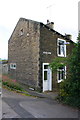
#3 Newtown Street
There is an OS benchmark Image on the near corner of the house, left hand face
Image: © Roger Templeman
Taken: 10 Aug 2015
0.10 miles
10
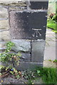
Benchmark on #3 Newtown Street
Ordnance Survey cut mark benchmark described on the Bench Mark Database at http://www.bench-marks.org.uk/bm46772
Image: © Roger Templeman
Taken: 10 Aug 2015
0.10 miles