IMAGES TAKEN NEAR TO
Albert Road, COLNE, BB8 0AA
Introduction
This page details the photographs taken nearby to Albert Road, BB8 0AA by members of the Geograph project.
The Geograph project started in 2005 with the aim of publishing, organising and preserving representative images for every square kilometre of Great Britain, Ireland and the Isle of Man.

There are currently over 7.5m images from over14,400 individuals and you can help contribute to the project by visiting https://www.geograph.org.uk
Image Map
Images are licensed for reuse under creativecommons.org/licenses/by-sa/2.0
Notes
- Clicking on the map will re-center to the selected point.
- The higher the marker number, the further away the image location is from the centre of the postcode.
Image Listing (268 Images Found)
Images are licensed for reuse under creativecommons.org/licenses/by-sa/2.0
Image
Details
Distance
2

Shackleton Hall, Colne, Lancashire
Was built as the Co Op Hall, now undergoing renovation
Image: © Robert Wade
Taken: 30 Aug 2010
0.01 miles
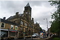
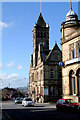
3
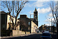
Colne, Lancashire: Albert Road and the Town Hall
Looking east
Image: © Dr Neil Clifton
Taken: 6 Mar 2007
0.02 miles
4
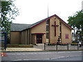
The Methodist Church, St John, Albert Road, Colne.
Image: © Alexander P Kapp
Taken: 22 Jul 2007
0.02 miles
5
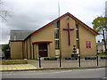
St Johns Methodist Church, 16, Albert Road, Colne, BB8 0RY
Image: © Robert Wade
Taken: 28 Oct 2009
0.02 miles

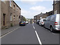
8
Albert Road, Colne
Looking south east on the A56.
Image: © JThomas
Taken: 2 Aug 2018
0.02 miles
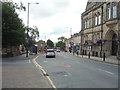
9
Colne, Lancashire: Town Hall looking west
Image: © Dr Neil Clifton
Taken: 6 Mar 2007
0.02 miles
10
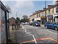
Albert Road - viewed from Church Street
Image: © Betty Longbottom
Taken: 28 May 2016
0.03 miles