IMAGES TAKEN NEAR TO
Cherry Tree Square, CLITHEROE, BB7 9ZT
Introduction
This page details the photographs taken nearby to Cherry Tree Square, BB7 9ZT by members of the Geograph project.
The Geograph project started in 2005 with the aim of publishing, organising and preserving representative images for every square kilometre of Great Britain, Ireland and the Isle of Man.

There are currently over 7.5m images from over14,400 individuals and you can help contribute to the project by visiting https://www.geograph.org.uk
Image Map
Images are licensed for reuse under creativecommons.org/licenses/by-sa/2.0
Notes
- Clicking on the map will re-center to the selected point.
- The higher the marker number, the further away the image location is from the centre of the postcode.
Image Listing (43 Images Found)
Images are licensed for reuse under creativecommons.org/licenses/by-sa/2.0
Image
Details
Distance
1
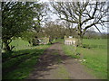
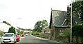
A Track West of Barrow
Track carrying a footpath near Barrow.
Image: © Chris Heaton
Taken: 27 Apr 2010
0.07 miles
2
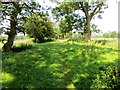
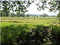
Footpath near Barrow
Leading through rough pasture.
Image: © philandju
Taken: 23 Jul 2014
0.10 miles
3
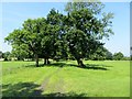
Footpath through farmland
Rough pasture to the right and hayfields to the left.
Image: © philandju
Taken: 23 Jul 2014
0.11 miles
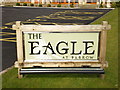
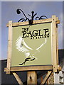
6
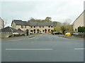
The Eagle at Barrow
The original name was The Spread Eagle, it closed had a refurbishment and a name change to Mon do which lasted for about 6maths then closed and then this
Image: © Alexander P Kapp
Taken: 12 Mar 2009
0.13 miles