IMAGES TAKEN NEAR TO
The Square, CLITHEROE, BB7 9SU
Introduction
This page details the photographs taken nearby to The Square, BB7 9SU by members of the Geograph project.
The Geograph project started in 2005 with the aim of publishing, organising and preserving representative images for every square kilometre of Great Britain, Ireland and the Isle of Man.

There are currently over 7.5m images from over14,400 individuals and you can help contribute to the project by visiting https://www.geograph.org.uk
Image Map (Loading...)


Getting Data...Please wait
Leaflet Map data © OpenStreetMap
Images are licensed for reuse under creativecommons.org/licenses/by-sa/2.0
Notes
- Clicking on the map will re-center to the selected point.
- The higher the marker number, the further away the image location is from the centre of the postcode.
Image Listing (549 Images Found)
Images are licensed for reuse under creativecommons.org/licenses/by-sa/2.0
Image
Details
Distance

3
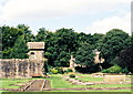
Ruins of Whalley Abbey
Cistercian monastery founded 1296 on earlier Christian site
Image: © Mike and Kirsty Grundy
Taken: 1 Aug 2005
0.02 miles

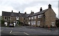
5

Footpath from Church Lane to King Street
Image: © Basher Eyre
Taken: 16 Aug 2017
0.03 miles
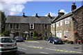
6
The Square, Whalley
Cottages near the parish church.
Image: © philandju
Taken: 8 May 2012
0.04 miles