IMAGES TAKEN NEAR TO
Calder Vale, CLITHEROE, BB7 9SR
Introduction
This page details the photographs taken nearby to Calder Vale, BB7 9SR by members of the Geograph project.
The Geograph project started in 2005 with the aim of publishing, organising and preserving representative images for every square kilometre of Great Britain, Ireland and the Isle of Man.

There are currently over 7.5m images from over14,400 individuals and you can help contribute to the project by visiting https://www.geograph.org.uk
Image Map
Images are licensed for reuse under creativecommons.org/licenses/by-sa/2.0
Notes
- Clicking on the map will re-center to the selected point.
- The higher the marker number, the further away the image location is from the centre of the postcode.
Image Listing (462 Images Found)
Images are licensed for reuse under creativecommons.org/licenses/by-sa/2.0
Image
Details
Distance
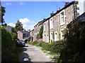
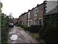
2
Calder Vale, Whalley
An unsurfaced side road, that further on becomes a footpath along the riverbank.
Image: © Stephen Craven
Taken: 25 Nov 2015
0.01 miles
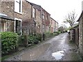
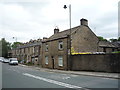
5
Calder Vale, Whalley
A row of stone cottages by the banks of the Calder.
Image: © philandju
Taken: 8 May 2012
0.01 miles
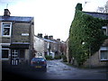
6
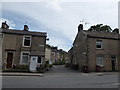
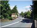
Junction of King Street and Calder Vale
Image: © Basher Eyre
Taken: 16 Aug 2017
0.02 miles
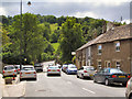
10
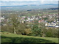
Whalley from the Nab
Taken on the way down from Whalley Nab and looking across the village towards Bowland, Lancashire.
Image: © Carroll Pierce
Taken: 3 Mar 2014
0.04 miles