IMAGES TAKEN NEAR TO
Whalley Road, CLITHEROE, BB7 9LG
Introduction
This page details the photographs taken nearby to Whalley Road, BB7 9LG by members of the Geograph project.
The Geograph project started in 2005 with the aim of publishing, organising and preserving representative images for every square kilometre of Great Britain, Ireland and the Isle of Man.

There are currently over 7.5m images from over14,400 individuals and you can help contribute to the project by visiting https://www.geograph.org.uk
Image Map
Images are licensed for reuse under creativecommons.org/licenses/by-sa/2.0
Notes
- Clicking on the map will re-center to the selected point.
- The higher the marker number, the further away the image location is from the centre of the postcode.
Image Listing (34 Images Found)
Images are licensed for reuse under creativecommons.org/licenses/by-sa/2.0
Image
Details
Distance
1
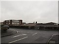
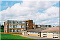
St Augustine's school, Billington
A Catholic high school. See also Image
Image: © Stephen Craven
Taken: 26 Nov 2015
0.05 miles
2
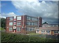
St Augustine's RC High School, Billington
Image: © John H Darch
Taken: 15 Aug 2014
0.06 miles
3
St Augustine's School Roman Catholic High School, Billington
Image: © JThomas
Taken: 16 Jul 2016
0.07 miles
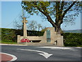
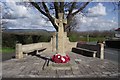
5
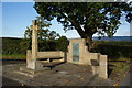
War memorial, Billington
At the western edge of the village.
Image: © Bill Boaden
Taken: 16 Oct 2010
0.08 miles
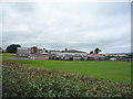
8
St Augustine's RC High School, Billington
Image: © Bill Boaden
Taken: 16 Oct 2010
0.09 miles
9
St Augustine's School. Billington
Image: © Mike and Kirsty Grundy
Taken: 1 Aug 2005
0.10 miles
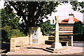
10

Pasturelands Drive, Billington
Part of a small estate of bungalows.
Image: © Stephen Craven
Taken: 26 Nov 2015
0.10 miles