IMAGES TAKEN NEAR TO
Clitheroe Road, CLITHEROE, BB7 9HX
Introduction
This page details the photographs taken nearby to Clitheroe Road, BB7 9HX by members of the Geograph project.
The Geograph project started in 2005 with the aim of publishing, organising and preserving representative images for every square kilometre of Great Britain, Ireland and the Isle of Man.

There are currently over 7.5m images from over14,400 individuals and you can help contribute to the project by visiting https://www.geograph.org.uk
Image Map (Loading...)


Getting Data...Please wait
Leaflet Map data © OpenStreetMap
Images are licensed for reuse under creativecommons.org/licenses/by-sa/2.0
Notes
- Clicking on the map will re-center to the selected point.
- The higher the marker number, the further away the image location is from the centre of the postcode.
Image Listing (75 Images Found)
Images are licensed for reuse under creativecommons.org/licenses/by-sa/2.0
Image
Details
Distance
2
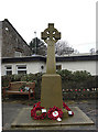
War memorial, Sabden
In a small garden of remembrance at the corner of Whalley Road and Padiham Road.
Image: © michael ely
Taken: 29 Jan 2009
0.02 miles
3
The War Memorial, Sabden
On the corner of Whalley Road and Clitheroe Road. Behind it is the old village school.
Image: © Bill Boaden
Taken: 19 Feb 2011
0.02 miles
4

Sabden War Memorial
The Sabden War Memorial is a relatively simple wheel cross standing on a plinth in a paved area outside the village primary school at the corner of Whalley Road and Clitheroe Road. The cross column carries the inscription “Pro Patria”. The dates “1914 – 1918” appear on each of the four sides of the pedestal above the list of names. On the fourth side below the last of the WW1 names is inscribed “1939 – 1945” ( and 4 further names).
Image: © David Dixon
Taken: 10 Nov 2017
0.02 miles
5
War Memorial at Sabden
The Sabden War Memorial is a relatively simple wheel cross standing on a plinth in a paved area outside the village primary school at the corner of Whalley Road and Clitheroe Road. The cross column carries the inscription “Pro Patria”. The dates “1914 – 1918” appear on each of the four sides of the pedestal above the list of names. On the fourth side below the last of the WW1 names is inscribed “1939 – 1945” ( and 4 further names).
Image: © David Dixon
Taken: 10 Nov 2017
0.02 miles
6
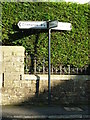
From Four Lane Ends
The three-fingered signpost at Four Lane Ends, Sabden, Lancashire (the fourth 'lane' being Wesley Road just off to the left of the signpost).
Image: © Carroll Pierce
Taken: 4 Nov 2013
0.03 miles
7

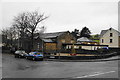
Clitheroe Road Baptist Sabden
A Baptist chapel in Sabden was founded before 1787,the building in this picture was in use when this image was taken.
Image: © Steve Houldsworth
Taken: Unknown
0.04 miles
8
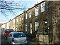
Gardeners Row
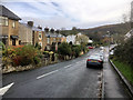
Gardeners Row, south end, Sabden, Lancashire
Image: © Carroll Pierce
Taken: 2 Jan 2015
0.05 miles
9
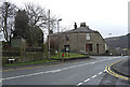
Padiham Road, Sabden
From the junction with Whalley Road. Turn right here, then left up St Nicholas Avenue to find the bridleway to Dean Farm.
Image: © michael ely
Taken: 29 Jan 2009
0.05 miles
10
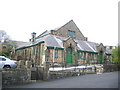
Sabden Baptist Chapel
Now in the old school at the rear of the old Chapel
Image: © Alexander P Kapp
Taken: 20 Apr 2007
0.05 miles