IMAGES TAKEN NEAR TO
Mill Street, CLITHEROE, BB7 4SR
Introduction
This page details the photographs taken nearby to Mill Street, BB7 4SR by members of the Geograph project.
The Geograph project started in 2005 with the aim of publishing, organising and preserving representative images for every square kilometre of Great Britain, Ireland and the Isle of Man.

There are currently over 7.5m images from over14,400 individuals and you can help contribute to the project by visiting https://www.geograph.org.uk
Image Map (Loading...)


Getting Data...Please wait
Leaflet Map data © OpenStreetMap
Images are licensed for reuse under creativecommons.org/licenses/by-sa/2.0
Notes
- Clicking on the map will re-center to the selected point.
- The higher the marker number, the further away the image location is from the centre of the postcode.
Image Listing (79 Images Found)
Images are licensed for reuse under creativecommons.org/licenses/by-sa/2.0
Image
Details
Distance
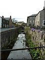
3
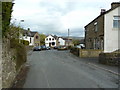
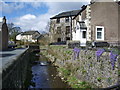
West Bradford
West Bradford Brook flowing here at the junction of Chapel Lane and Clitheroe Road.
Image: © philandju
Taken: 6 May 2013
0.01 miles
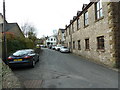
6
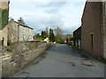
Chapel Lane off Clitheroe Road, West Bradford
Image: © Alexander P Kapp
Taken: 7 Apr 2012
0.03 miles
7
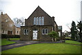
The Methodist Church, West Bradford
Image: © Alexander P Kapp
Taken: 13 Jan 2006
0.03 miles
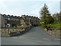
9
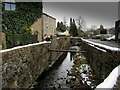
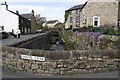
West Bradford Brook beside Clitheroe Road
The brook running through the village of West Bradford
Image: © Chris Heaton
Taken: 24 Jan 2013
0.04 miles