IMAGES TAKEN NEAR TO
Sawley, CLITHEROE, BB7 4LG
Introduction
This page details the photographs taken nearby to BB7 4LG by members of the Geograph project.
The Geograph project started in 2005 with the aim of publishing, organising and preserving representative images for every square kilometre of Great Britain, Ireland and the Isle of Man.

There are currently over 7.5m images from over14,400 individuals and you can help contribute to the project by visiting https://www.geograph.org.uk
Image Map (Loading...)


Getting Data...Please wait
Leaflet Map data © OpenStreetMap
Images are licensed for reuse under creativecommons.org/licenses/by-sa/2.0
Notes
- Clicking on the map will re-center to the selected point.
- The higher the marker number, the further away the image location is from the centre of the postcode.
Image Listing (13 Images Found)
Images are licensed for reuse under creativecommons.org/licenses/by-sa/2.0
Image
Details
Distance
1
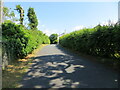
Hedge enclosed minor road at Brow Top
Looking south-eastward.
Image: © Peter Wood
Taken: 30 Jun 2021
0.01 miles
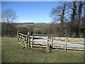
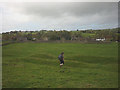
2
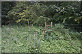
Footpath no longer operating
The stile is still there, but as a local resident stated, nobody uses it any more. There is a way round without going too far, but it means walking along the A59 for a bit.
Image: © Bill Boaden
Taken: 1 Aug 2015
0.14 miles
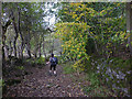

6
Stile beside the A59
Footpath approaching a stile that gives access to cross the A59 and continue down to the village of Sawley beside the River Ribble.
Image: © Chris Heaton
Taken: 2 Mar 2010
0.16 miles
7
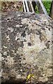
Benchmark on top of parapet of bridge taking track over Hollins Syke
Ordnance Survey rivet benchmark levelled at 78.547m above Newlyn Datum verified 1967
Image: © Roger Templeman
Taken: 19 Jul 2024
0.17 miles
8
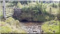
Small bridge taking track over Hollins Syke
There is an Ordnance Survey benchmark Image on top of the top stone at the left hand end of the parapet
Image: © Roger Templeman
Taken: 19 Jul 2024
0.18 miles
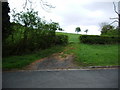
9
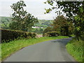
Lane above Sawley
The lane connects the village to the busy A59.
Image: © Phil Platt
Taken: 21 Sep 2010
0.18 miles
10
Earthworks east of Sawley Abbey
In Sawley Park, just east of the abbey ruins, are prominent earthworks which may be man-made. There are straight lines which may be old field boundaries and what may once have been a water channel running across one of the meanders of the nearby Ribble.
Image: © Karl and Ali
Taken: 18 Oct 2014
0.21 miles