IMAGES TAKEN NEAR TO
Stocks Lane, CLITHEROE, BB7 4JR
Introduction
This page details the photographs taken nearby to Stocks Lane, BB7 4JR by members of the Geograph project.
The Geograph project started in 2005 with the aim of publishing, organising and preserving representative images for every square kilometre of Great Britain, Ireland and the Isle of Man.

There are currently over 7.5m images from over14,400 individuals and you can help contribute to the project by visiting https://www.geograph.org.uk
Image Map
Images are licensed for reuse under creativecommons.org/licenses/by-sa/2.0
Notes
- Clicking on the map will re-center to the selected point.
- The higher the marker number, the further away the image location is from the centre of the postcode.
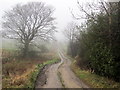
Image Listing (11 Images Found)
Images are licensed for reuse under creativecommons.org/licenses/by-sa/2.0
Image
Details
Distance
4

Commemorative stone
The white rose is denoting that the parish was in Yorkshire and the red that it is now in Lancashire
Image: © Alexander P Kapp
Taken: 15 Mar 2013
0.04 miles
7
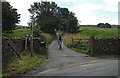
Pennine Bridleway Lane Side
The cyclist is on Coal Pit Lane at the junction with Brogden Lane.
Image: © michael ely
Taken: 8 Aug 2013
0.05 miles
8
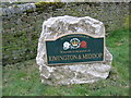
Commemorative Stone
This commemorative stone welcoming people to the parish of Rimington & Middop can be found at the roadside at the junction of Coal Pit Lane, Stocks Lane and Brogden Lane.
Image: © Scott Henderson
Taken: 16 Mar 2008
0.05 miles
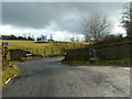
9
Coal Pit Lane
Unmetalled Lane descending gradually towards the Ribble Valley, recently adopted by the Pennine Bridleway.
Image: © Chris Heaton
Taken: 11 Jan 2012
0.14 miles