IMAGES TAKEN NEAR TO
Skipton Road, CLITHEROE, BB7 4HP
Introduction
This page details the photographs taken nearby to Skipton Road, BB7 4HP by members of the Geograph project.
The Geograph project started in 2005 with the aim of publishing, organising and preserving representative images for every square kilometre of Great Britain, Ireland and the Isle of Man.

There are currently over 7.5m images from over14,400 individuals and you can help contribute to the project by visiting https://www.geograph.org.uk
Image Map (Loading...)


Getting Data...Please wait
Leaflet Map data © OpenStreetMap
Images are licensed for reuse under creativecommons.org/licenses/by-sa/2.0
Notes
- Clicking on the map will re-center to the selected point.
- The higher the marker number, the further away the image location is from the centre of the postcode.
Image Listing (13 Images Found)
Images are licensed for reuse under creativecommons.org/licenses/by-sa/2.0
Image
Details
Distance
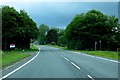
1
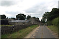
Gisburn: Driveway to Greengates Farm
Some 20 or so years ago, the A59 was straightened and improved in this area and I suspect that this drive formed part of the old alignment of the road.
Image: © Dr Neil Clifton
Taken: 2 Aug 2013
0.04 miles
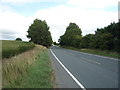
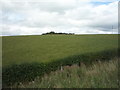
8
Grazing near Greengates
Looking south towards Sullside Hill.
Image: © JThomas
Taken: 2 Aug 2018
0.17 miles
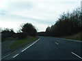
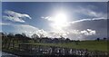
9

Walter Hill
Approaching the summit of Walter Hill near Gisburn - one of many drumlins that abound in this area
Image: © Chris Heaton
Taken: 11 Jan 2012
0.18 miles
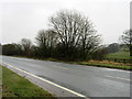
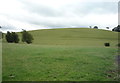
10
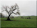
Below Walter Hill Plantation
Lonely tree on Walter Hill.
Image: © Chris Heaton
Taken: 11 Jan 2012
0.19 miles