IMAGES TAKEN NEAR TO
Howgill Lane, CLITHEROE, BB7 4EF
Introduction
This page details the photographs taken nearby to Howgill Lane, BB7 4EF by members of the Geograph project.
The Geograph project started in 2005 with the aim of publishing, organising and preserving representative images for every square kilometre of Great Britain, Ireland and the Isle of Man.

There are currently over 7.5m images from over14,400 individuals and you can help contribute to the project by visiting https://www.geograph.org.uk
Image Map
Images are licensed for reuse under creativecommons.org/licenses/by-sa/2.0
Notes
- Clicking on the map will re-center to the selected point.
- The higher the marker number, the further away the image location is from the centre of the postcode.
Image Listing (8 Images Found)
Images are licensed for reuse under creativecommons.org/licenses/by-sa/2.0
Image
Details
Distance

4
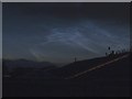
Noctilucent Clouds over Pendle
Photograph taken just before midnight. The clouds seemed to appear quickly. They were not visible 30 minutes earlier. The orange spot is a helicopter.
Image: © Chris Tomlinson
Taken: 30 May 2013
0.12 miles
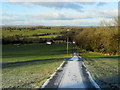
5
Drive to Raikes Farm
The long drive to the farmhouse.
Image: © Maigheach-gheal
Taken: 17 Oct 2010
0.17 miles
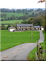
6
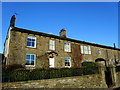
Howgill Farm
Dwellings on Howgill Lane near Rimington
Image: © Chris Heaton
Taken: 5 Dec 2012
0.17 miles
7
Access Lane to Rakes Barn
A frosty scene near Martin Top, Rimington
Image: © Chris Heaton
Taken: 5 Dec 2012
0.20 miles
