IMAGES TAKEN NEAR TO
Rimington Lane, CLITHEROE, BB7 4EA
Introduction
This page details the photographs taken nearby to Rimington Lane, BB7 4EA by members of the Geograph project.
The Geograph project started in 2005 with the aim of publishing, organising and preserving representative images for every square kilometre of Great Britain, Ireland and the Isle of Man.

There are currently over 7.5m images from over14,400 individuals and you can help contribute to the project by visiting https://www.geograph.org.uk
Image Map (Loading...)


Getting Data...Please wait
Leaflet Map data © OpenStreetMap
Images are licensed for reuse under creativecommons.org/licenses/by-sa/2.0
Notes
- Clicking on the map will re-center to the selected point.
- The higher the marker number, the further away the image location is from the centre of the postcode.
Image Listing (11 Images Found)
Images are licensed for reuse under creativecommons.org/licenses/by-sa/2.0
Image
Details
Distance
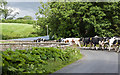
1
Rimmington Bridge
Ewe with three new born lambs
Image: © Peter Moore
Taken: 11 Feb 2012
0.10 miles
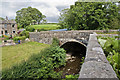
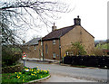
3
Rimington Lane near Rimington Bridge
Image: © Dr Neil Clifton
Taken: 20 Apr 2006
0.10 miles
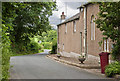
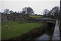
6
Cottages near Rimington Bridge
At this point the lane from Rimington to the A682 bends sharply as it crosses the bridge over Stankill Beck.
Image: © Dr Neil Clifton
Taken: 20 Apr 2006
0.13 miles
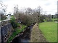
8

Pasture beside Stankill Beck
Country scene in winter as witnessed from Rimington Bridge - looking upstream along the course of Stankill Beck
Image: © Chris Heaton
Taken: 5 Dec 2012
0.13 miles
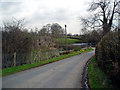
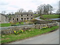
10
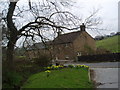
Halstead's Farm, Rimington
On the lane from Rimington towards the A682.
Image: © Dr Neil Clifton
Taken: 20 Apr 2006
0.21 miles