IMAGES TAKEN NEAR TO
Slaidburn Road, CLITHEROE, BB7 3JJ
Introduction
This page details the photographs taken nearby to Slaidburn Road, BB7 3JJ by members of the Geograph project.
The Geograph project started in 2005 with the aim of publishing, organising and preserving representative images for every square kilometre of Great Britain, Ireland and the Isle of Man.

There are currently over 7.5m images from over14,400 individuals and you can help contribute to the project by visiting https://www.geograph.org.uk
Image Map
Images are licensed for reuse under creativecommons.org/licenses/by-sa/2.0
Notes
- Clicking on the map will re-center to the selected point.
- The higher the marker number, the further away the image location is from the centre of the postcode.
Image Listing (6 Images Found)
Images are licensed for reuse under creativecommons.org/licenses/by-sa/2.0
Image
Details
Distance
1
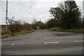
Mill Lane
A short lane off the Waddington to Newton in Bowland road
Image: © Alexander P Kapp
Taken: 29 Mar 2006
0.09 miles
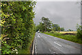
3

A pair of stiles
Two planks serve as a footbridge between http://www.geograph.org.uk/photo/4555009
Image: © Ian Greig
Taken: 3 Jul 2015
0.14 miles
4
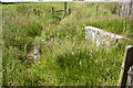
Two planks serve as a footbridge over a hidden stream
The engraving looks like a date, 1667 or 1867. Given the material, neither is credible. Close inspection reveals it to be JB67.
Image: © Ian Greig
Taken: 3 Jul 2015
0.14 miles
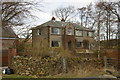
6
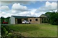
The Annexe, Cuttock Clough House
A dull house with fantastic views
Image: © Alex McGregor
Taken: 6 Jun 2012
0.21 miles