IMAGES TAKEN NEAR TO
Waddington Road, CLITHEROE, BB7 3JF
Introduction
This page details the photographs taken nearby to Waddington Road, BB7 3JF by members of the Geograph project.
The Geograph project started in 2005 with the aim of publishing, organising and preserving representative images for every square kilometre of Great Britain, Ireland and the Isle of Man.

There are currently over 7.5m images from over14,400 individuals and you can help contribute to the project by visiting https://www.geograph.org.uk
Image Map (Loading...)


Getting Data...Please wait
Leaflet Map data © OpenStreetMap
Images are licensed for reuse under creativecommons.org/licenses/by-sa/2.0
Notes
- Clicking on the map will re-center to the selected point.
- The higher the marker number, the further away the image location is from the centre of the postcode.
Image Listing (8 Images Found)
Images are licensed for reuse under creativecommons.org/licenses/by-sa/2.0
Image
Details
Distance
1
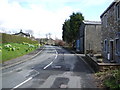
Waddington Road
Heading north east towards West Bradford.
Image: © JThomas
Taken: 1 Oct 2016
0.18 miles
2

Edward VII postbox on Waddington Road, Lane Side
Postbox No. BB7 425.
See Image] for context.
Image: © JThomas
Taken: 1 Oct 2016
0.18 miles
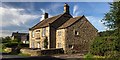
4

House, Lane Side
On Waddington Road.
Showing position of Postbox No. BB7 425.
See Image] for postbox.
Image: © JThomas
Taken: 1 Oct 2016
0.19 miles
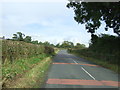
5
Waddington Road at Waddington village boundary
Image: © Colin Pyle
Taken: 7 Jan 2015
0.19 miles
6
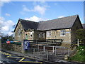
Waddington and West Bradford Primary School
Image: © Alexander P Kapp
Taken: 6 Apr 2008
0.19 miles
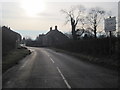
7
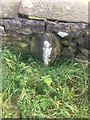
Old Boundary Marker
Parish Boundary Marker on the southeast side of Waddington Road between Waddington and West Bradford. On the boundary of Waddington and West Bradford parishes, formerly in the West Riding of Yorkshire but now Lancashire.
Milestone Society National ID: YW_WADWBR01pb
Image: © W MacDonald
Taken: 10 Nov 2019
0.20 miles