IMAGES TAKEN NEAR TO
Whitewell Road, CLITHEROE, BB7 3DG
Introduction
This page details the photographs taken nearby to Whitewell Road, BB7 3DG by members of the Geograph project.
The Geograph project started in 2005 with the aim of publishing, organising and preserving representative images for every square kilometre of Great Britain, Ireland and the Isle of Man.

There are currently over 7.5m images from over14,400 individuals and you can help contribute to the project by visiting https://www.geograph.org.uk
Image Map
Images are licensed for reuse under creativecommons.org/licenses/by-sa/2.0
Notes
- Clicking on the map will re-center to the selected point.
- The higher the marker number, the further away the image location is from the centre of the postcode.
Image Listing (4 Images Found)
Images are licensed for reuse under creativecommons.org/licenses/by-sa/2.0
Image
Details
Distance
1
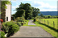
Leaving Lees House Farm
A track leads south east beside Limes Wood
Image: © Chris Heaton
Taken: 7 Sep 2015
0.07 miles
3
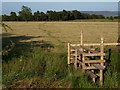
Stile over ditch on footpath Lees House Farm
This is the second stile on the footpath leading from Limes Wood, looking back over the field towards Limes Wood.
Image: © Steve Houldsworth
Taken: 2 Jul 2011
0.22 miles
4
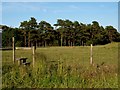
Stile in field lees House Farm
The stile over the fence on the footpath leading from Limes Wood over the field at Lees House Farm looking back towards Limes Wood.
Image: © Steve Houldsworth
Taken: 2 Jul 2011
0.22 miles