IMAGES TAKEN NEAR TO
Little Bowland Road, CLITHEROE, BB7 3BN
Introduction
This page details the photographs taken nearby to Little Bowland Road, BB7 3BN by members of the Geograph project.
The Geograph project started in 2005 with the aim of publishing, organising and preserving representative images for every square kilometre of Great Britain, Ireland and the Isle of Man.

There are currently over 7.5m images from over14,400 individuals and you can help contribute to the project by visiting https://www.geograph.org.uk
Image Map (Loading...)


Getting Data...Please wait
Leaflet Map data © OpenStreetMap
Images are licensed for reuse under creativecommons.org/licenses/by-sa/2.0
Notes
- Clicking on the map will re-center to the selected point.
- The higher the marker number, the further away the image location is from the centre of the postcode.
Image Listing (19 Images Found)
Images are licensed for reuse under creativecommons.org/licenses/by-sa/2.0
Image
Details
Distance
3
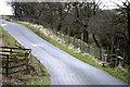
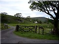
The road to Whitmore
The white house which can be seen is Tunstall Ing
Image: © Alexander P Kapp
Taken: 28 Jul 2007
0.12 miles
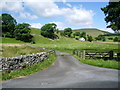
4
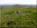
Long Knots
Parked at road junction near telephone box and entrance to Drinkley Green Farm. Walked up the road then take the footpath on the right to access the upper slopes so you can walk north over the two tops of Long Knots.
Name: Long Knots
Hill number: 108731
Height: 256m / 840ft
Area: 36: Lancashire, Cheshire & the Southern Pennines
Class: 2
Grid ref: SD643471 (est)
Drop: 31m
Col: 225m
Image: © Rude Health
Taken: 9 Dec 2013
0.13 miles
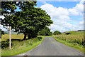
7
The road to Dunsop Bridge
Approaching Burholme Bridge.
Image: © philandju
Taken: 9 Aug 2022
0.16 miles
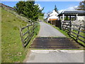
8

It just seems to be pointing at something
Image: © Alexander P Kapp
Taken: 28 Jul 2007
0.16 miles
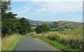
9

A View over the Hodder Valley (1)
From, slightly north of Tunstall Ing - a stunning view eastwards over the Hodder Valley and Bowland countryside.
Image: © Chris Heaton
Taken: 28 Jul 2017
0.18 miles