IMAGES TAKEN NEAR TO
Slaidburn, CLITHEROE, BB7 3AE
Introduction
This page details the photographs taken nearby to BB7 3AE by members of the Geograph project.
The Geograph project started in 2005 with the aim of publishing, organising and preserving representative images for every square kilometre of Great Britain, Ireland and the Isle of Man.

There are currently over 7.5m images from over14,400 individuals and you can help contribute to the project by visiting https://www.geograph.org.uk
Image Map (Loading...)


Getting Data...Please wait
Leaflet Map data © OpenStreetMap
Images are licensed for reuse under creativecommons.org/licenses/by-sa/2.0
Notes
- Clicking on the map will re-center to the selected point.
- The higher the marker number, the further away the image location is from the centre of the postcode.
Image Listing (188 Images Found)
Images are licensed for reuse under creativecommons.org/licenses/by-sa/2.0
Image
Details
Distance
1
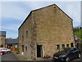
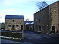
Poorlands Farm
Now accommodation for several small business's. Viewed from the south.
Image: © Peter Wood
Taken: 6 Jun 2014
0.02 miles
2
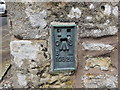
Ordnance Survey Flush Bracket 10828
This can be found on the wall of the former Poorlands Farm. Now being used by several small buildings.
http://www.bench-marks.org.uk/bm11089
Image: © Peter Wood
Taken: 6 Jun 2014
0.02 miles
3
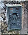
Ordnance Survey Flush Bracket (10828)
This OS cut mark can be found on the conversion at Poorlands Farm. It marks a point 141.593m above mean sea level.
Image: © Adrian Dust
Taken: 22 Nov 2019
0.02 miles
4

Plaque Poor'sland Barn
A replica of the original, which is kept in Unit 9 http://www.slaidburnvillagehall.com/slaidburnlocal/site/poorsland.htm
Image: © Alexander P Kapp
Taken: 9 Mar 2008
0.03 miles
6
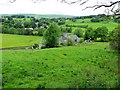
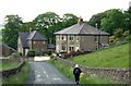
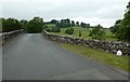
Approaching Slaidburn
The road behind the houses is Slaidburn Bridge over the River Hodder.
Image: © philandju
Taken: 17 Jun 2014
0.04 miles
7
Poor'sland Barn
http://www.slaidburnvillagehall.com/slaidburnlocal/site/poorsland.htm
Image: © Alexander P Kapp
Taken: 9 Mar 2008
0.04 miles
8
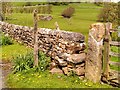
Footpath Sign and Stone Stile
Footpath sign and stone stile on the other side of the river from Slaidburn.
Image: © David Dixon
Taken: 7 May 2015
0.04 miles
9
Entering Slaidburn
Approaching Slaidburn Bridge which spans the River Hodder. Also known as New Bridge, it was built in the late 18th century and is grade II listed.
Image: © philandju
Taken: 22 Jun 2022
0.04 miles
10
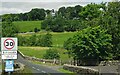
Old Boundary Marker
County Bridge Marker at the northeast end of New Bridge, River Hodder, on the B6478. Slaidburn parish. WR in raised lettering on both faces marking the extent of roadway adjoining the bridge that the County was obliged to maintain.
Milestone Society National ID: YW_SLB02br
Image: © M Bardell
Taken: 10 Jul 2019
0.04 miles