IMAGES TAKEN NEAR TO
Garnett Mews, BB7 2SR
Introduction
This page details the photographs taken nearby to Garnett Mews, BB7 2SR by members of the Geograph project.
The Geograph project started in 2005 with the aim of publishing, organising and preserving representative images for every square kilometre of Great Britain, Ireland and the Isle of Man.

There are currently over 7.5m images from over14,400 individuals and you can help contribute to the project by visiting https://www.geograph.org.uk
Image Map
Images are licensed for reuse under creativecommons.org/licenses/by-sa/2.0
Notes
- Clicking on the map will re-center to the selected point.
- The higher the marker number, the further away the image location is from the centre of the postcode.
Image Listing (55 Images Found)
Images are licensed for reuse under creativecommons.org/licenses/by-sa/2.0
Image
Details
Distance
1
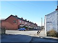
St Paul's Street, Low Moor, Clitheroe
The main street of this former industrial village. Clitheroe's first cotton mill was built at Low Moor in 1782, and the village grew to house the workers.
Image: © Christine Johnstone
Taken: 12 Mar 2013
0.02 miles
2
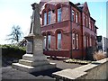
War memorial, Low Moor, Clitheroe
In the grounds of Low Moor Club, on St Paul's Street.
Image: © Christine Johnstone
Taken: 12 Mar 2013
0.03 miles
3
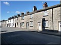
Mill workers' houses, St Paul's Street, Low Moor
Clitheroe's first cotton spinning mill was built in Low Moor in 1782, and terraces like these were built to house the workers. For details of Clitheroe's built history, see www.lancashire.gov.uk/ environment/ documents/ historictowns/ ClitheroeComplete_LowRes.pdf .
Image: © Christine Johnstone
Taken: 12 Mar 2013
0.05 miles
4
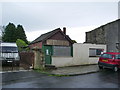
Formerly the local fish and chip shop
Image: © Alexander P Kapp
Taken: 4 May 2008
0.07 miles
5
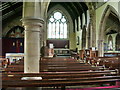
St Paul's Church, Low Moor, Clitheroe, Interior
Image: © Alexander P Kapp
Taken: 4 May 2008
0.07 miles
6
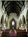
St Paul's Church, Low Moor, Clitheroe, Interior
Image: © Alexander P Kapp
Taken: 4 May 2008
0.07 miles
7
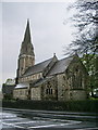
St Paul's Church, Low Moor, Clitheroe
Image: © Alexander P Kapp
Taken: 4 May 2008
0.07 miles
8

St Paul's Church, Low Moor, Clitheroe, Porch
Image: © Alexander P Kapp
Taken: 4 May 2008
0.07 miles
9
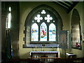
St Paul's Church, Low Moor, Clitheroe, Side chapel
Image: © Alexander P Kapp
Taken: 4 May 2008
0.07 miles
10
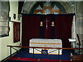
St Paul's Church, Low Moor, Clitheroe, Side chapel
Dedicated to The Royal Engineers Association. During the WWII Royal Engineers were stationed in Low Moor Mill (now demolished) and this was the local church. http://www.army.mod.uk/royalengineers/rea/
Image: © Alexander P Kapp
Taken: 4 May 2008
0.08 miles