IMAGES TAKEN NEAR TO
Chapel Close, CLITHEROE, BB7 2QT
Introduction
This page details the photographs taken nearby to Chapel Close, BB7 2QT by members of the Geograph project.
The Geograph project started in 2005 with the aim of publishing, organising and preserving representative images for every square kilometre of Great Britain, Ireland and the Isle of Man.

There are currently over 7.5m images from over14,400 individuals and you can help contribute to the project by visiting https://www.geograph.org.uk
Image Map
Images are licensed for reuse under creativecommons.org/licenses/by-sa/2.0
Notes
- Clicking on the map will re-center to the selected point.
- The higher the marker number, the further away the image location is from the centre of the postcode.
Image Listing (36 Images Found)
Images are licensed for reuse under creativecommons.org/licenses/by-sa/2.0
Image
Details
Distance
1
Ribble Way between Low Moor and Brungerley Bridge
Image: © John H Darch
Taken: 7 Nov 2009
0.01 miles
2
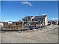
Low Moor Gardens
Taylow Wimpey's housing development on the northern edge of Low Moor, Clitheroe.
Image: © Christine Johnstone
Taken: 12 Mar 2013
0.03 miles
3
Low Moor Gardens
New greenfield housing on the edge of Low Moor.
Image: © Bill Boaden
Taken: 20 Dec 2013
0.03 miles
4
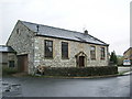
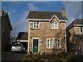
Former Wesleyan Methodist Chapel
Originally the building was the Chapel them a new one was built at the end of Nelson Street, when it was used as a Sunday School. Now it is a house and workshop
Image: © Alexander P Kapp
Taken: 4 May 2008
0.05 miles
6
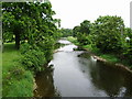
River Ribble south of Grindleton
Looking upstream from footbridge
Image: © Alexander P Kapp
Taken: 3 Jun 2007
0.07 miles
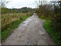
7
!["Onto a track that runs past the allotments" [1]](https://s1.geograph.org.uk/geophotos/03/37/27/3372741_d1466b67_120x120.jpg)
"Onto a track that runs past the allotments" [1]
Section 3 of Walk No 1, Clitheroe Walks http://www.visitlancashire.com/things-to-do/walking-routes/walks-under-5-miles . Also part of the Ribble Way.
Image: © Christine Johnstone
Taken: 12 Mar 2013
0.07 miles
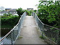
8
New footbridge over the River Ribble, Low Moor
This is the replacement for the old concrete bridge http://www.geograph.org.uk/photo/455050. The old bridge was locally known as Spring Bridge as you could get a good bounce when jumping up and down, not with this one it is solid as a rock.
Image: © Alexander P Kapp
Taken: 15 Dec 2009
0.08 miles
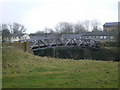
9
Footbridge
Spans the River Ribble at Low Moor, soon to be replaced with a wooden Bridge
Image: © Alexander P Kapp
Taken: 3 Jun 2007
0.09 miles
10
!["Onto a track that runs past the allotments" [2]](https://s2.geograph.org.uk/geophotos/03/37/27/3372746_b3bbe658_120x120.jpg)
"Onto a track that runs past the allotments" [2]
Section 3 of Walk No 1, Clitheroe Walks http://www.visitlancashire.com/things-to-do/walking-routes/walks-under-5-miles . Also part of the Ribble Way.
Image: © Christine Johnstone
Taken: 12 Mar 2013
0.09 miles