IMAGES TAKEN NEAR TO
Edisford Road, CLITHEROE, BB7 2LT
Introduction
This page details the photographs taken nearby to Edisford Road, BB7 2LT by members of the Geograph project.
The Geograph project started in 2005 with the aim of publishing, organising and preserving representative images for every square kilometre of Great Britain, Ireland and the Isle of Man.

There are currently over 7.5m images from over14,400 individuals and you can help contribute to the project by visiting https://www.geograph.org.uk
Image Map
Images are licensed for reuse under creativecommons.org/licenses/by-sa/2.0
Notes
- Clicking on the map will re-center to the selected point.
- The higher the marker number, the further away the image location is from the centre of the postcode.
Image Listing (37 Images Found)
Images are licensed for reuse under creativecommons.org/licenses/by-sa/2.0
Image
Details
Distance
1
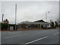
Disused car show room, Edisford Road, Clitheore
Image: © Alexander P Kapp
Taken: 4 Nov 2010
0.02 miles
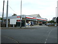
2
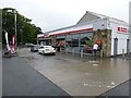
Spar Supermarket
Edisford Road, Clitheroe.
Image: © Russel Wills
Taken: 13 Aug 2016
0.04 miles
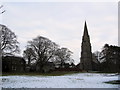
4
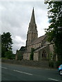
Low Moor Church, Clitheroe
on a grey day
Image: © Mike and Kirsty Grundy
Taken: 14 Sep 2005
0.07 miles
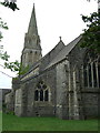
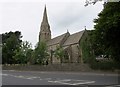
7
St. Paul's
St. Paul's Church at Low Moor.
Image: © Peter McDermott
Taken: 4 May 2015
0.09 miles
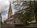
9
St. Paul's, Low Moor
Church of England parish church.
Image: © philandju
Taken: 30 Aug 2013
0.10 miles
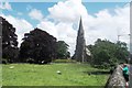
10
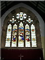
St Paul's Church, Low Moor, Clitheroe, East window
Image: © Alexander P Kapp
Taken: 4 May 2008
0.10 miles