IMAGES TAKEN NEAR TO
Henthorn Road, CLITHEROE, BB7 2LD
Introduction
This page details the photographs taken nearby to Henthorn Road, BB7 2LD by members of the Geograph project.
The Geograph project started in 2005 with the aim of publishing, organising and preserving representative images for every square kilometre of Great Britain, Ireland and the Isle of Man.

There are currently over 7.5m images from over14,400 individuals and you can help contribute to the project by visiting https://www.geograph.org.uk
Image Map
Images are licensed for reuse under creativecommons.org/licenses/by-sa/2.0
Notes
- Clicking on the map will re-center to the selected point.
- The higher the marker number, the further away the image location is from the centre of the postcode.
Image Listing (47 Images Found)
Images are licensed for reuse under creativecommons.org/licenses/by-sa/2.0
Image
Details
Distance
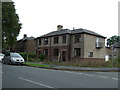
3
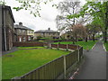
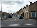
Interwar council housing
The small grass crescent is a common feature in 1920s council estates.
Image: © John M
Taken: 9 May 2018
0.11 miles
4
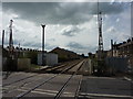
Clitheroe to Blackburn Railway
Looking SE towards Blackburn from the level crossing on Eshton terrace
Image: © Alexander P Kapp
Taken: 8 May 2010
0.11 miles
7
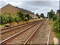
Railway Track, Looking South from Eshton Terrace
Image: © David Dixon
Taken: 16 Aug 2015
0.12 miles
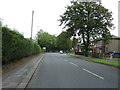
10
Eshton Terrace looking towards the level crossing.
Image: © Colin Pyle
Taken: 23 Mar 2010
0.12 miles