IMAGES TAKEN NEAR TO
Stamford Place, CLITHEROE, BB7 1NT
Introduction
This page details the photographs taken nearby to Stamford Place, BB7 1NT by members of the Geograph project.
The Geograph project started in 2005 with the aim of publishing, organising and preserving representative images for every square kilometre of Great Britain, Ireland and the Isle of Man.

There are currently over 7.5m images from over14,400 individuals and you can help contribute to the project by visiting https://www.geograph.org.uk
Image Map (Loading...)


Getting Data...Please wait
Leaflet Map data © OpenStreetMap
Images are licensed for reuse under creativecommons.org/licenses/by-sa/2.0
Notes
- Clicking on the map will re-center to the selected point.
- The higher the marker number, the further away the image location is from the centre of the postcode.
Image Listing (302 Images Found)
Images are licensed for reuse under creativecommons.org/licenses/by-sa/2.0
Image
Details
Distance

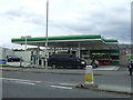
3
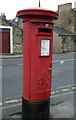
George VI postbox on the A671, Clitheroe
Postbox No. BB7 402.
See Image] for context.
Image: © JThomas
Taken: 24 Sep 2016
0.04 miles
4
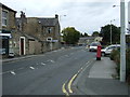
A671, Clitheroe
Showing position of Postbox No. BB7 402.
See Image] for postbox.
Image: © JThomas
Taken: 24 Sep 2016
0.04 miles
6
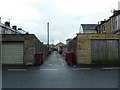
Back street off Waterloo Road, Clitheroe
Image: © Alexander P Kapp
Taken: 16 Mar 2013
0.05 miles

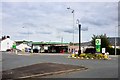
10
Service station on Chatburn Road (A671), Clitheroe
Image: © JThomas
Taken: 24 Sep 2016
0.06 miles